|
search place name
|
||
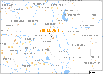
Barlovento (Cesar, Colombia)Barlovento is a town in the Cesar region of Colombia. An overview map of the region around Barlovento is displayed below.
regional and 3d topo map of Barlovento, Colombia ::
Barlovento airports ::
The nearest airport is VUP - Valledupar Alfonso Lopez Pumarejo, located 115.0 km north east of Barlovento.
Other airports nearby include MGN - Magangue Baracoa (129.4 km west), OCV - Ocana Aguas Claras (134.8 km south), CZU - Corozal Las Brujas (176.6 km west), SMR - Santa Marta Simon Bolivar (189.9 km north), Nearby towns ::
Villa Hermosa (0.6km south east) //
San Andrés (2.3km north east) //
San José (3.0km south west) //
San Cayetano (3.5km south) //
Media Luna (3.6km north) //
Rancho Viejo (3.9km west) //
Bijagual (4.2km south) //
Potrerillo (5.9km north east) //
Venecia (6.3km south) //
Los Indios (6.3km north east) //
Matepalma (7.1km north) //
La Matica (7.6km south east) //
Celedón (7.9km west) //
Primavera (8.0km north west) //
Puntetigre (8.1km east) //
Concepción (8.9km north east) //
Las Delicias (9.2km south west) //
Boca de Potrero (10.1km north east) //
La Carolina (10.3km north east) //
La Brillantina (10.6km south west) //
Playón de La Tumba (11.6km south east) //
[all distances 'as the bird flies' and approximate] 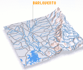 Places with similar names to Barlovento, Colombia ::
// Barlovento (CU)
// Barlovento (ES)
// Barlovento (CO)
// Barlovento (CO)
// Barlovento (MX)
// Barlovento (VE)
// Barlovento (VE)
// Barlovento (VE)
// Barlovento (VE)
Disclaimer :: Information on this page comes without warranty of any kind |
||
|
Where is Barlovento? Elevation and coordinates ::
Latitude (lat): 9°29'22"N Longitude (lon): 73°41'9"W
Elevation (approx.): 35m (map arrows pan, magnifying glasses zoom) |
||
|
Visiting Barlovento? Hotel/Accommodation ::
Book a hotel in Barlovento Travel Guide ::
Buy a travel guide for Colombia rental cars ::
car rental offers GPS waypoint ::
download a GPX waypoint (PoI) of Barlovento for your GPS receiver
|
||