|
search place name
|
||
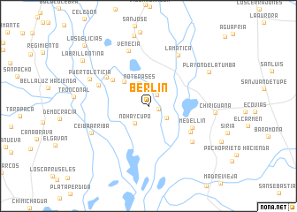
Berlín (Cesar, Colombia)Berlín is a town in the Cesar region of Colombia. An overview map of the region around Berlín is displayed below.
regional and 3d topo map of Berlín, Colombia ::
Berlín airports ::
The nearest airport is OCV - Ocana Aguas Claras, located 122.5 km south of Berlín.
Other airports nearby include VUP - Valledupar Alfonso Lopez Pumarejo (126.6 km north), MGN - Magangue Baracoa (128.2 km west), CZU - Corozal Las Brujas (176.1 km west), STB - Santa Barbara Del Zulia (196.3 km east), Nearby towns ::
Cara Santa (1.3km east) //
El Tigre (1.8km north east) //
Puerto Jarava (2.7km south east) //
No Hay Cupo (2.7km south west) //
No Te Pases (3.0km north) //
Hasta Aquí Llegaste (4.3km north west) //
Remolino (5.5km north west) //
Medellín (6.1km south east) //
La Sarama (6.1km south east) //
La Palma (6.4km north west) //
La Lucha (6.7km north west) //
Carbonero (7.1km south east) //
Venecia (7.4km north) //
La Matica (7.4km north east) //
Ceiba Arriba (7.8km south west) //
Puerto Leticia (8.1km north west) //
Chiriguaná (8.4km east) //
Playón de La Tumba (8.7km north east) //
Bijagual (9.1km north) //
La Brillantina (10.0km north west) //
Las Delicias (11.0km north west) //
[all distances 'as the bird flies' and approximate]  Places with similar names to Berlín, Colombia ::
Disclaimer :: Information on this page comes without warranty of any kind |
||
|
Where is Berlín? Elevation and coordinates ::
Latitude (lat): 9°22'27"N Longitude (lon): 73°40'58"W
Elevation (approx.): 25m (map arrows pan, magnifying glasses zoom) |
||
|
Visiting Berlín? Hotel/Accommodation ::
Book a hotel in Berlín Travel Guide ::
Buy a travel guide for Colombia rental cars ::
car rental offers GPS waypoint ::
download a GPX waypoint (PoI) of Berlín for your GPS receiver
|
||