|
search place name
|
||
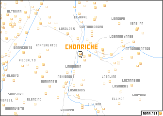
Chonriche (Santander, Colombia)Chonriche is a town in the Santander region of Colombia. An overview map of the region around Chonriche is displayed below.
regional and 3d topo map of Chonriche, Colombia ::
Chonriche airports ::
The nearest airport is BGA - Bucaramanga Palonegro, located 95.8 km north of Chonriche.
Other airports nearby include EJA - Barrancabermeja Yariguies (111.4 km north west), TME - Tame (155.1 km east), STD - Santo Domingo Mayor Buenaventura Vivas (189.7 km north east), SVZ - San Antonio Del Tachira (191.5 km north east), Nearby towns ::
San Luis (0.5km north west) //
Montefrío (0.8km north east) //
La Angostura (0.9km south east) //
Resguardo (1.9km east) //
Charalá (2.9km north) //
La Ronda (3.5km north east) //
La Morena (3.6km south west) //
El Llano (3.9km north east) //
Coleota (3.9km south west) //
Riachuelo (4.0km north east) //
Macanal (4.3km north) //
Caraota (4.6km north) //
Vahondo (4.5km east) //
El Cedro (4.7km south west) //
La Capellanía (4.9km north east) //
Guacamayas (5.1km south) //
Las Flores (5.1km east) //
Coromorito (5.2km north east) //
Trompeto (5.2km east) //
Coromorito (5.2km north east) //
Rositania (5.6km north west) //
Miraflores (5.8km north east) //
San Cayetano (6.2km south) //
El Olvido (6.5km south) //
Los Alpes (6.5km north west) //
Nemisaque (6.5km south west) //
Santa Barbara (6.6km north) //
La Vega (6.9km south west) //
Caparosa (6.9km east) //
[all distances 'as the bird flies' and approximate] 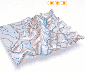 Places with similar names to Chonriche, Colombia ::
Disclaimer :: Information on this page comes without warranty of any kind |
||
|
Where is Chonriche? Elevation and coordinates ::
Latitude (lat): 6°15'39"N Longitude (lon): 73°8'58"W
Elevation (approx.): 1341m (map arrows pan, magnifying glasses zoom) |
||
|
Visiting Chonriche? Hotel/Accommodation ::
Book a hotel in Chonriche Travel Guide ::
Buy a travel guide for Colombia rental cars ::
car rental offers GPS waypoint ::
download a GPX waypoint (PoI) of Chonriche for your GPS receiver
|
||