|
search place name
|
||
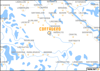
Contadero (Bolívar, Colombia)Contadero is a town in the Bolívar region of Colombia. An overview map of the region around Contadero is displayed below.
regional and 3d topo map of Contadero, Colombia ::
Contadero airports ::
The nearest airport is MGN - Magangue Baracoa, located 66.2 km north west of Contadero.
Other airports nearby include CZU - Corozal Las Brujas (113.6 km west), OCV - Ocana Aguas Claras (130.9 km south east), MTR - Monteria Los Garzones (170.4 km west), VUP - Valledupar Alfonso Lopez Pumarejo (191.4 km north east), Nearby towns ::
Los Palitos (1.6km south east) //
Corocito (3.1km north east) //
Mamoncito (3.2km east) //
Los Mangos (3.2km north east) //
La Esperanza (4.7km north west) //
Las Cabezas (4.9km north east) //
Santa Rosa (5.9km north) //
Las Mesas (6.7km north west) //
Las Mesas (6.7km north west) //
Baranoa (7.2km south) //
Destacamento (7.6km south) //
Guadual (7.7km north) //
El Palmar (7.9km north west) //
Pampanillo (8.1km north west) //
Media Luna (8.3km west) //
Caimital (8.6km east) //
Santa Helena (8.9km north west) //
Se Verá (9.0km north east) //
Calamar (9.2km south west) //
Pueblo Nuevo (9.5km south west) //
La Estrella (10.8km south west) //
La Vista (10.8km south west) //
Chilloa (11.3km north east) //
[all distances 'as the bird flies' and approximate]  Places with similar names to Contadero, Colombia ::
Disclaimer :: Information on this page comes without warranty of any kind |
||
|
Where is Contadero? Elevation and coordinates ::
Latitude (lat): 9°2'52"N Longitude (lon): 74°17'34"W
Elevation (approx.): 23m (map arrows pan, magnifying glasses zoom) |
||
|
Visiting Contadero? Hotel/Accommodation ::
Book a hotel in Contadero Travel Guide ::
Buy a travel guide for Colombia rental cars ::
car rental offers GPS waypoint ::
download a GPX waypoint (PoI) of Contadero for your GPS receiver
|
||