|
search place name
|
||
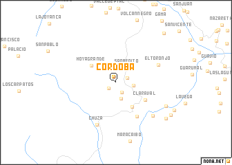
Córdoba (Cundinamarca, Colombia)Córdoba is a town in the Cundinamarca region of Colombia. An overview map of the region around Córdoba is displayed below.
regional and 3d topo map of Córdoba, Colombia ::
Córdoba airports ::
The nearest airport is BOG - Bogota Eldorado Intl, located 51.8 km west of Córdoba.
Other airports nearby include VVC - Villavicencio Vanguardia (56.7 km south), IBE - Ibague Perales (163.6 km west), MZL - Manizales La Nubia (201.7 km west), MDE - Rio Negro Jose Maria Cordova (253.7 km north west), Nearby towns ::
San José (1.5km south west) //
Miraflores (1.9km south east) //
Terama (2.0km east) //
Chorrillos (2.8km south) //
La Aldea (2.9km east) //
San Benito (3.0km north east) //
Chuscales (4.7km south east) //
Hoya Grande (4.8km north west) //
Claraval (5.6km south east) //
El Carmen (6.5km south east) //
El Toronjo (7.4km north east) //
Chuza (7.6km south west) //
Ríonegro (8.0km south east) //
Chisguates (8.9km south east) //
El Cedra (10.0km south east) //
Cocubal (10.3km south east) //
La Palma (11.1km north east) //
[all distances 'as the bird flies' and approximate] 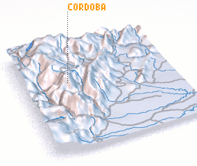 Places with similar names to Córdoba, Colombia ::
Disclaimer :: Information on this page comes without warranty of any kind |
||
|
Where is Córdoba? Elevation and coordinates ::
Latitude (lat): 4°40'33"N Longitude (lon): 73°40'51"W
Elevation (approx.): 2375m (map arrows pan, magnifying glasses zoom) |
||
|
Visiting Córdoba? Hotel/Accommodation ::
Book a hotel in Córdoba Travel Guide ::
Buy a travel guide for Colombia rental cars ::
car rental offers GPS waypoint ::
download a GPX waypoint (PoI) of Córdoba for your GPS receiver
|
||