|
search place name
|
||
Cucharal (Cundinamarca, Colombia)Cucharal is a town in the Cundinamarca region of Colombia. An overview map of the region around Cucharal is displayed below.
regional and 3d topo map of Cucharal, Colombia ::

Cucharal airports ::
The nearest airport is BOG - Bogota Eldorado Intl, located 69.4 km south east of Cucharal.
Other airports nearby include MZL - Manizales La Nubia (94.5 km west), IBE - Ibague Perales (95.9 km south west), PEI - Pereira Matecana (129.0 km west), MDE - Rio Negro Jose Maria Cordova (146.3 km north west), Nearby towns ::
Versalles (2.6km north east) //
Paramillo (5.6km south) //
Samaria (5.6km south) //
Guacamayas (5.6km north) //
Cocoló (5.6km north) //
Guaduas (5.6km south) //
San José (5.8km east) //
Tabaquera (6.7km north east) //
El Palmar (7.6km east) //
La Argentina (7.6km south) //
Chipauta (7.8km south east) //
Granada (7.8km south east) //
Monte Frío (8.3km south east) //
La Esperanza (9.2km north west) //
El Columpio (9.2km south east) //
[all distances 'as the bird flies' and approximate] 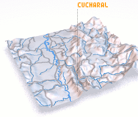 Places with similar names to Cucharal, Colombia ::
// Kochar-Eli (UA)
// Cachorrilla (ES)
// Cucharal (ES)
// Kucherla (RU)
// Cucharal (CO)
// Cucharal (CO)
// Güicheral (CO)
// Keshrol (IN)
// Cachirulo (VE)
// Cucharal (VE)
Disclaimer :: Information on this page comes without warranty of any kind |
||
|
Where is Cucharal? Elevation and coordinates ::
Latitude (lat): 5°7'0"N Longitude (lon): 74°37'0"W
Elevation (approx.): 937m (map arrows pan, magnifying glasses zoom) |
||
|
Visiting Cucharal? Hotel/Accommodation ::
Book a hotel in Cucharal Travel Guide ::
Buy a travel guide for Colombia rental cars ::
car rental offers GPS waypoint ::
download a GPX waypoint (PoI) of Cucharal for your GPS receiver
|
||