|
search place name
|
||
Ecovias (Cesar, Colombia)Ecovias is a town in the Cesar region of Colombia. An overview map of the region around Ecovias is displayed below.
regional and 3d topo map of Ecovias, Colombia ::

Ecovias airports ::
The nearest airport is OCV - Ocana Aguas Claras, located 118.6 km south of Ecovias.
Other airports nearby include VUP - Valledupar Alfonso Lopez Pumarejo (122.9 km north), MGN - Magangue Baracoa (141.4 km west), STB - Santa Barbara Del Zulia (183.2 km east), LFR - La Fria (189.1 km south east), Nearby towns ::
Campo Clavo (1.2km west) //
El Carmen (2.0km south west) //
San Juan de Tupe (3.1km north) //
Baramona (3.6km south east) //
Siria (4.4km south west) //
Chiriguaná (4.9km west) //
San Luis (5.5km north east) //
El Clavo (5.7km south west) //
Hacienda Pacho Prieto (6.0km south west) //
La Matica (6.9km south west) //
Playón de La Tumba (7.6km north west) //
Medellín (8.1km west) //
La Sarama (8.5km west) //
Carbonero (8.7km south west) //
Rincón Hondo (8.8km east) //
Santa Isabel (9.6km south east) //
San Roque (10.6km south east) //
[all distances 'as the bird flies' and approximate] 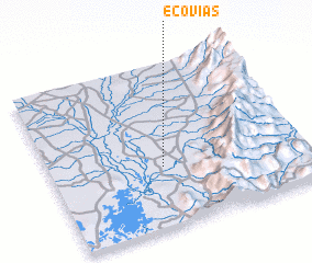 Places with similar names to Ecovias, Colombia ::
// Écouviez (FR)
Disclaimer :: Information on this page comes without warranty of any kind |
||
|
Where is Ecovias? Elevation and coordinates ::
Latitude (lat): 9°22'5"N Longitude (lon): 73°33'43"W
Elevation (approx.): 36m (map arrows pan, magnifying glasses zoom) |
||
|
Visiting Ecovias? Hotel/Accommodation ::
Book a hotel in Ecovias Travel Guide ::
Buy a travel guide for Colombia rental cars ::
car rental offers GPS waypoint ::
download a GPX waypoint (PoI) of Ecovias for your GPS receiver
|
||