|
search place name
|
||
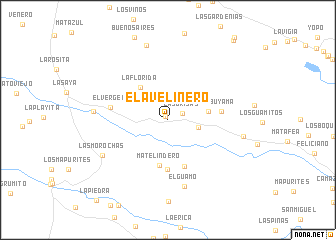
El Avelinero (Departamento de Arauca, Colombia)El Avelinero is a town in the Departamento de Arauca region of Colombia. An overview map of the region around El Avelinero is displayed below.
regional and 3d topo map of El Avelinero, Colombia ::
El Avelinero airports ::
The nearest airport is AUC - Arauca Santiago Perez, located 25.1 km north west of El Avelinero.
Other airports nearby include TME - Tame (132.8 km west), STD - Santo Domingo Mayor Buenaventura Vivas (173.0 km north west), MRD - Merida Alberto Carnevalli (198.5 km north), BNS - Barinas (199.1 km north), Nearby towns ::
El Lamero (0.4km north west) //
Las Brisas (1.8km east) //
Matequintero (3.5km east) //
Matetranquero (3.6km north west) //
Avelinero (4.6km east) //
La Florida (4.7km north west) //
Matelindero (5.1km south) //
El Jobal (5.5km south) //
Delicias (5.6km south) //
Abuyama (6.0km east) //
El Vergel (6.5km west) //
El Guamo (7.6km south) //
Las Morochas (8.3km south west) //
Matecaña (8.3km west) //
Jobito (8.6km north) //
Los Malaguetos (8.6km east) //
[all distances 'as the bird flies' and approximate] 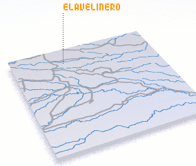 Places with similar names to El Avelinero, Colombia :: Disclaimer :: Information on this page comes without warranty of any kind |
||
|
Where is El Avelinero? Elevation and coordinates ::
Latitude (lat): 6°52'0"N Longitude (lon): 70°38'0"W
Elevation (approx.): 120m (map arrows pan, magnifying glasses zoom) |
||
|
Visiting El Avelinero? Hotel/Accommodation ::
Book a hotel in El Avelinero Travel Guide ::
Buy a travel guide for Colombia rental cars ::
car rental offers GPS waypoint ::
download a GPX waypoint (PoI) of El Avelinero for your GPS receiver
|
||