|
search place name
|
||
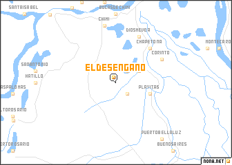
El Desengaño (Bolívar, Colombia)El Desengaño is a town in the Bolívar region of Colombia. An overview map of the region around El Desengaño is displayed below.
regional and 3d topo map of El Desengaño, Colombia ::
El Desengaño airports ::
The nearest airport is OCV - Ocana Aguas Claras, located 93.6 km south east of El Desengaño.
Other airports nearby include MGN - Magangue Baracoa (103.1 km north west), CZU - Corozal Las Brujas (149.4 km west), VUP - Valledupar Alfonso Lopez Pumarejo (194.5 km north east), CUC - Cucuta Camilo Daza (194.6 km south east), Nearby towns ::
Pueblo Nuevo (2.6km north east) //
El Delirio (2.6km south east) //
La Risa (4.1km north east) //
Playitas (5.8km east) //
Chapetona (7.8km north east) //
Corinto (8.2km north east) //
Diosmevea (8.3km north east) //
[all distances 'as the bird flies' and approximate] 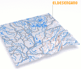 Places with similar names to El Desengaño, Colombia ::
// El Desengaño (CU)
// El Desengaño (CU)
// El Desengaño (CU)
// El Desengaño (CO)
// El Desengaño (CO)
// El Desengaño (GT)
// El Desengaño (MX)
// El Desengaño (MX)
// El Desengaño (MX)
// El Desengaño (MX)
Disclaimer :: Information on this page comes without warranty of any kind |
||
|
Where is El Desengaño? Elevation and coordinates ::
Latitude (lat): 8°51'0"N Longitude (lon): 74°1'0"W
Elevation (approx.): 42m (map arrows pan, magnifying glasses zoom) |
||
|
Visiting El Desengaño? Hotel/Accommodation ::
Book a hotel in El Desengaño Travel Guide ::
Buy a travel guide for Colombia rental cars ::
car rental offers GPS waypoint ::
download a GPX waypoint (PoI) of El Desengaño for your GPS receiver
|
||