|
search place name
|
||
Gramasverdes (Cesar, Colombia)Gramasverdes is a town in the Cesar region of Colombia. An overview map of the region around Gramasverdes is displayed below.
regional and 3d topo map of Gramasverdes, Colombia ::

Gramasverdes airports ::
The nearest airport is VUP - Valledupar Alfonso Lopez Pumarejo, located 66.9 km north of Gramasverdes.
Other airports nearby include OCV - Ocana Aguas Claras (168.0 km south), SMR - Santa Marta Simon Bolivar (174.0 km north west), STB - Santa Barbara Del Zulia (178.2 km south east), MGN - Magangue Baracoa (178.6 km west), Nearby towns ::
Sicarare (3.9km west) //
Casacará (5.9km east) //
Rincón de Hatillo (6.0km south) //
Zorro (6.7km south west) //
Don Quijote (7.6km south west) //
Zorro (8.0km south) //
Nuevo Mundo (8.6km north) //
Pedregal (8.7km south) //
Santa Eulalia (8.8km south west) //
El Hatillo (9.0km south east) //
Llerasea (9.1km east) //
Guadalajara (9.7km north west) //
La Mariela (10.0km north east) //
Nibal (10.1km south east) //
La Danta (10.7km north west) //
La Fe (11.1km north east) //
[all distances 'as the bird flies' and approximate] 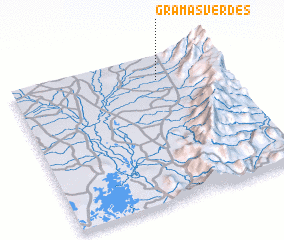 Places with similar names to Gramasverdes, Colombia :: Disclaimer :: Information on this page comes without warranty of any kind |
||
|
Where is Gramasverdes? Elevation and coordinates ::
Latitude (lat): 9°50'0"N Longitude (lon): 73°18'57"W
Elevation (approx.): 83m (map arrows pan, magnifying glasses zoom) |
||
|
Visiting Gramasverdes? Hotel/Accommodation ::
Book a hotel in Gramasverdes Travel Guide ::
Buy a travel guide for Colombia rental cars ::
car rental offers GPS waypoint ::
download a GPX waypoint (PoI) of Gramasverdes for your GPS receiver
|
||