|
search place name
|
||
La Mesa Baja (Quindío, Colombia)La Mesa Baja is a town in the Quindío region of Colombia. An overview map of the region around La Mesa Baja is displayed below.
regional and 3d topo map of La Mesa Baja, Colombia ::

La Mesa Baja airports ::
The nearest airport is PEI - Pereira Matecana, located 18.8 km north of La Mesa Baja.
Other airports nearby include AXM - Armenia El Eden (21.2 km south), MZL - Manizales La Nubia (52.7 km north east), IBE - Ibague Perales (71.8 km east), ULQ - Tulua Farfan (82.2 km south west), Nearby towns ::
Rubiela (2.7km north east) //
Quimbaya (3.2km south west) //
La Cuchilla (3.5km north east) //
Pavas (3.7km east) //
Maravélez (4.6km north east) //
La Española (5.3km south east) //
Alcalá (5.7km north west) //
Chapinero (5.8km north east) //
Playa Verde (6.4km north west) //
Ulloa (6.8km north) //
El Jazmín (6.9km west) //
Pueblorrico (6.9km south) //
Barcelona Baja (7.0km south east) //
La Siria (7.5km south east) //
La Frontera (7.6km south) //
Montezuma (7.9km north) //
Tres Esquinas (8.1km north) //
La India (8.1km north east) //
El Jazmín (8.3km west) //
Quebrada Membrillal (8.5km east) //
Montenegro (8.6km south) //
Arabia (8.8km north) //
Piamonte (9.0km south east) //
Betulia (9.1km north) //
El Laurel (9.4km south west) //
Villarazo (9.4km south east) //
Alsacia (9.5km north east) //
Dinamarca (9.9km north west) //
La Pola (10.3km south east) //
[all distances 'as the bird flies' and approximate] 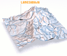 Places with similar names to La Mesa Baja, Colombia ::
// Llames Bajo (ES)
Disclaimer :: Information on this page comes without warranty of any kind |
||
|
Where is La Mesa Baja? Elevation and coordinates ::
Latitude (lat): 4°38'35"N Longitude (lon): 75°44'31"W
Elevation (approx.): 1390m (map arrows pan, magnifying glasses zoom) |
||
|
Visiting La Mesa Baja? Hotel/Accommodation ::
Book a hotel in La Mesa Baja Travel Guide ::
Buy a travel guide for Colombia rental cars ::
car rental offers GPS waypoint ::
download a GPX waypoint (PoI) of La Mesa Baja for your GPS receiver
|
||