|
search place name
|
||
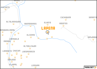
La Peña (Santander, Colombia)La Peña is a town in the Santander region of Colombia. An overview map of the region around La Peña is displayed below.
regional and 3d topo map of La Peña, Colombia ::
La Peña airports ::
The nearest airport is BGA - Bucaramanga Palonegro, located 77.0 km north of La Peña.
Other airports nearby include EJA - Barrancabermeja Yariguies (107.2 km north west), TME - Tame (140.1 km east), STD - Santo Domingo Mayor Buenaventura Vivas (165.1 km north east), SVZ - San Antonio Del Tachira (167.1 km north east), Nearby towns ::
Guare (1.6km south east) //
Lomita de Suárez (1.8km south) //
El Hoyo (3.8km north) //
La Victoria (4.1km west) //
Mogotes (6.7km north east) //
El Cerro (6.8km west) //
Buenos Aires (7.6km north west) //
Cuchiquira (8.8km north east) //
Alto El Cajón (9.0km south west) //
La Esperanza (10.8km south west) //
Monchía (12.1km south west) //
[all distances 'as the bird flies' and approximate] 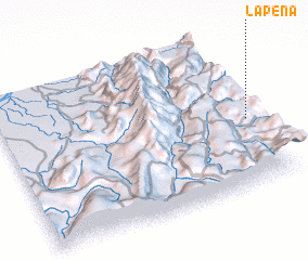 Places with similar names to La Peña, Colombia ::
Disclaimer :: Information on this page comes without warranty of any kind |
||
|
Where is La Peña? Elevation and coordinates ::
Latitude (lat): 6°26'54"N Longitude (lon): 73°1'36"W
Elevation (approx.): 1646m (map arrows pan, magnifying glasses zoom) |
||
|
Visiting La Peña? Hotel/Accommodation ::
Book a hotel in La Peña Travel Guide ::
Buy a travel guide for Colombia rental cars ::
car rental offers GPS waypoint ::
download a GPX waypoint (PoI) of La Peña for your GPS receiver
|
||