|
search place name
|
||
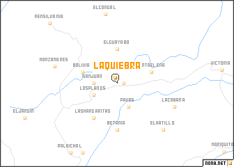
La Quiebra (Caldas, Colombia)La Quiebra is a town in the Caldas region of Colombia. An overview map of the region around La Quiebra is displayed below.
regional and 3d topo map of La Quiebra, Colombia ::
La Quiebra airports ::
The nearest airport is MZL - Manizales La Nubia, located 53.3 km south west of La Quiebra.
Other airports nearby include PEI - Pereira Matecana (92.0 km south west), IBE - Ibague Perales (97.4 km south), MDE - Rio Negro Jose Maria Cordova (103.4 km north), EOH - Medellin Olaya Herrera (117.1 km north west), Nearby towns ::
Marquetalia (1.1km east) //
San Juan (3.7km west) //
Los Planes (4.1km south west) //
Pavas (4.1km south east) //
El Guayabo (5.6km north) //
Santa Elena (5.8km east) //
Bolivia (5.8km west) //
Las Margaritas (6.7km south west) //
Betania (7.4km south) //
El Hatillo (10.5km south east) //
[all distances 'as the bird flies' and approximate]  Places with similar names to La Quiebra, Colombia ::
// Lagabura (ET)
// La Cabera (CU)
// Logobare (BA)
// Logobare (BA)
// Lagbéré (BJ)
// La Gabarra (CO)
// La Quiebra (CO)
// La Quiebra (CO)
// La Quiebra (CO)
// La Quiebra (CO)
Disclaimer :: Information on this page comes without warranty of any kind |
||
|
Where is La Quiebra? Elevation and coordinates ::
Latitude (lat): 5°18'0"N Longitude (lon): 75°4'0"W
Elevation (approx.): 1466m (map arrows pan, magnifying glasses zoom) |
||
|
Visiting La Quiebra? Hotel/Accommodation ::
Book a hotel in La Quiebra Travel Guide ::
Buy a travel guide for Colombia rental cars ::
car rental offers GPS waypoint ::
download a GPX waypoint (PoI) of La Quiebra for your GPS receiver
|
||