|
search place name
|
||
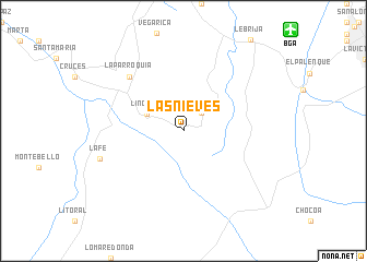
Las Nieves (Santander, Colombia)Las Nieves is a town in the Santander region of Colombia. An overview map of the region around Las Nieves is displayed below.
regional and 3d topo map of Las Nieves, Colombia ::
Las Nieves airports ::
The nearest airport is BGA - Bucaramanga Palonegro, located 15.0 km north east of Las Nieves.
Other airports nearby include EJA - Barrancabermeja Yariguies (57.8 km west), SVZ - San Antonio Del Tachira (129.0 km north east), CUC - Cucuta Camilo Daza (130.5 km north east), OCV - Ocana Aguas Claras (142.0 km north), Nearby towns ::
Motoso (2.6km north east) //
Lincoln (4.1km north west) //
La Parroquia (7.8km north west) //
La Fe (8.9km west) //
[all distances 'as the bird flies' and approximate] 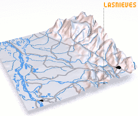 Places with similar names to Las Nieves, Colombia ::
// Las Navas (PH)
// Las Navas (PH)
// Las Nieves (PH)
// Liucinavas (LT)
// Las Nuevas (CU)
// Las Nuevas (CU)
// Las Nuevas (CU)
// Las Nuevas (CU)
// Las Navas (ES)
// Las Navas (ES)
Disclaimer :: Information on this page comes without warranty of any kind |
||
|
Where is Las Nieves? Elevation and coordinates ::
Latitude (lat): 7°2'0"N Longitude (lon): 73°17'0"W
Elevation (approx.): 1029m (map arrows pan, magnifying glasses zoom) |
||
|
Visiting Las Nieves? Hotel/Accommodation ::
Book a hotel in Las Nieves Travel Guide ::
Buy a travel guide for Colombia rental cars ::
car rental offers GPS waypoint ::
download a GPX waypoint (PoI) of Las Nieves for your GPS receiver
|
||