|
search place name
|
||
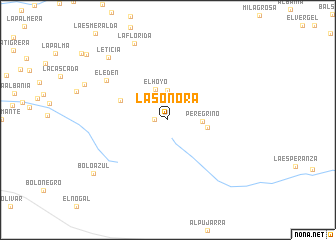
La Sonora (Tolima, Colombia)La Sonora is a town in the Tolima region of Colombia. An overview map of the region around La Sonora is displayed below.
regional and 3d topo map of La Sonora, Colombia ::
La Sonora airports ::
The nearest airport is CLO - Cali Alfonso Bonilla Aragon Intl, located 45.4 km west of La Sonora.
Other airports nearby include ULQ - Tulua Farfan (70.8 km north west), NVA - Neiva Benito Salas (97.4 km south east), AXM - Armenia El Eden (107.5 km north), BUN - Buenaventura Gerardo Tobar Lopez (118.0 km west), Nearby towns ::
La Base (1.5km west) //
Buenos Aires (3.3km north) //
El Hoyo (3.7km north) //
Peregrino (3.9km east) //
Las Palmas (4.4km east) //
El Brillante (5.7km west) //
El Edén (8.2km north west) //
La Florida (9.3km north west) //
Leticia (9.6km north west) //
Bolo Azul (10.2km south west) //
[all distances 'as the bird flies' and approximate] 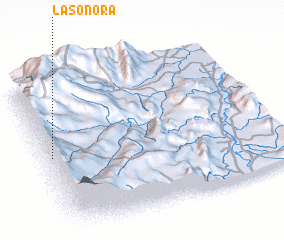 Places with similar names to La Sonora, Colombia ::
// Louisenruh (DE)
// Ličinari (BA)
// Ličinari (BA)
// La Sienra (ES)
// La Sainera (CO)
// La Señora (CO)
// La Sonora (CO)
// La Sonora (CO)
// La Sonora (CO)
// La Sonora (CO)
Disclaimer :: Information on this page comes without warranty of any kind |
||
|
Where is La Sonora? Elevation and coordinates ::
Latitude (lat): 3°30'14"N Longitude (lon): 75°58'31"W
Elevation (approx.): 3149m (map arrows pan, magnifying glasses zoom) |
||
|
Visiting La Sonora? Hotel/Accommodation ::
Book a hotel in La Sonora Travel Guide ::
Buy a travel guide for Colombia rental cars ::
car rental offers GPS waypoint ::
download a GPX waypoint (PoI) of La Sonora for your GPS receiver
|
||