|
search place name
|
||
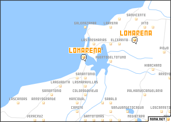
Lomarena (Bolívar, Colombia)Lomarena is a town in the Bolívar region of Colombia. An overview map of the region around Lomarena is displayed below.
regional and 3d topo map of Lomarena, Colombia ::
Lomarena airports ::
The nearest airport is CTG - Cartagena Rafael Nunez, located 42.0 km south west of Lomarena.
Other airports nearby include BAQ - Barranquilla Ernesto Cortissoz (55.9 km east), SMR - Santa Marta Simon Bolivar (121.0 km east), CZU - Corozal Las Brujas (154.9 km south), MGN - Magangue Baracoa (166.7 km south), Nearby towns ::
Pueblo Nuevo (1.9km north) //
San Andrés (2.6km north east) //
San Antonio (3.7km south) //
Rancho Grande (4.1km south west) //
Las Tres Marías (4.1km north east) //
Puerto del Totumo (5.5km east) //
Las Maravillas (5.6km south) //
Hueso de Vaca (6.6km north east) //
Colorado Viejo (7.4km south) //
Colorado (7.4km south) //
Galerazamba (7.4km north) //
La Aguadita (7.8km south west) //
El Cerrito (8.2km north east) //
La Arena (9.2km north east) //
San Antonio (10.4km south west) //
[all distances 'as the bird flies' and approximate]  Places with similar names to Lomarena, Colombia ::
// La Méreune (CH)
// Lumbrein (CH)
// Lomorni (ET)
// La Marina (PA)
// La Marina (IT)
// La Mariana (CU)
// La Mariana (CU)
// La Maraña (ES)
// La Mariana (ES)
// La Marina (ES)
Disclaimer :: Information on this page comes without warranty of any kind |
||
|
Where is Lomarena? Elevation and coordinates ::
Latitude (lat): 10°44'0"N Longitude (lon): 75°16'0"W
Elevation (approx.): 8m (map arrows pan, magnifying glasses zoom) |
||
|
Visiting Lomarena? Hotel/Accommodation ::
Book a hotel in Lomarena Travel Guide ::
Buy a travel guide for Colombia rental cars ::
car rental offers GPS waypoint ::
download a GPX waypoint (PoI) of Lomarena for your GPS receiver
|
||