|
search place name
|
||
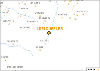
Los Laureles (Huila, Colombia)Los Laureles is a town in the Huila region of Colombia. An overview map of the region around Los Laureles is displayed below.
regional and 3d topo map of Los Laureles, Colombia ::
Los Laureles airports ::
The nearest airport is NVA - Neiva Benito Salas, located 48.6 km west of Los Laureles.
Other airports nearby include SVI - San Vincente De Caguan Eduardo Falla Solano (105.6 km south), IBE - Ibague Perales (148.8 km north), CLO - Cali Alfonso Bonilla Aragon Intl (173.6 km west), AXM - Armenia El Eden (178.9 km north west), Nearby towns ::
Dolores (3.6km south west) //
Patía (5.2km north west) //
La Soledad (5.9km north) //
Miramar (6.7km south west) //
La Batalla (7.5km north west) //
La Alegría (8.1km north east) //
San Isidro (8.3km north west) //
Corinto (9.9km north east) //
[all distances 'as the bird flies' and approximate] 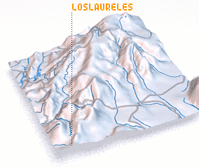 Places with similar names to Los Laureles, Colombia ::
// Los Laureles (CU)
// Los Laureles (CL)
// Los Laureles (CL)
// Los Laureles (CL)
// Los Laureles (CO)
// Los Laureles (CO)
// Los Laureles (CO)
// Los Laureles (CO)
// Los Laureles (CO)
// Los Laureles (CO)
Disclaimer :: Information on this page comes without warranty of any kind |
||
|
Where is Los Laureles? Elevation and coordinates ::
Latitude (lat): 3°6'0"N Longitude (lon): 74°53'0"W
Elevation (approx.): 2006m (map arrows pan, magnifying glasses zoom) |
||
|
Visiting Los Laureles? Hotel/Accommodation ::
Book a hotel in Los Laureles Travel Guide ::
Buy a travel guide for Colombia rental cars ::
car rental offers GPS waypoint ::
download a GPX waypoint (PoI) of Los Laureles for your GPS receiver
|
||