|
search place name
|
||
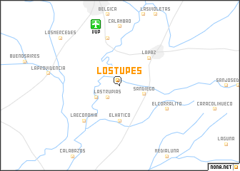
Los Tupes (Cesar, Colombia)Los Tupes is a town in the Cesar region of Colombia. An overview map of the region around Los Tupes is displayed below.
regional and 3d topo map of Los Tupes, Colombia ::
Los Tupes airports ::
The nearest airport is VUP - Valledupar Alfonso Lopez Pumarejo, located 10.1 km north of Los Tupes.
Other airports nearby include RCH - Rio Hacha Almirante Padilla (133.9 km north), SMR - Santa Marta Simon Bolivar (139.8 km north west), MAR - Maracaibo La Chinita Intl (164.6 km east), BAQ - Barranquilla Ernesto Cortissoz (181.3 km west), Nearby towns ::
Las Trupias (2.6km south west) //
San Diego (4.0km east) //
Las Moradas (4.1km south west) //
El Hatico (5.6km south) //
La Paz (6.3km north east) //
El Carmen (7.6km north) //
Algarrobillito (7.8km south west) //
La Economía (7.8km south west) //
El Corralito (8.2km south east) //
[all distances 'as the bird flies' and approximate] 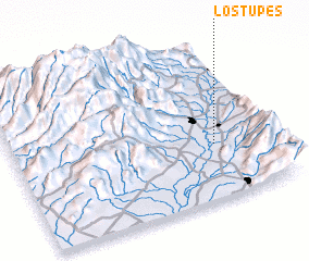 Places with similar names to Los Tupes, Colombia ::
// Las Tapias (CO)
// Las Tapias (CO)
// Las Tapias (CO)
// Las Tapias (CO)
// Las Tapias (CO)
// Las Tapias (SV)
// Las Tapias (GT)
// Las Tapias (GT)
// Las Tapias (GT)
// Las Tapias (MX)
Disclaimer :: Information on this page comes without warranty of any kind |
||
|
Where is Los Tupes? Elevation and coordinates ::
Latitude (lat): 10°21'0"N Longitude (lon): 73°13'0"W
Elevation (approx.): 118m (map arrows pan, magnifying glasses zoom) |
||
|
Visiting Los Tupes? Hotel/Accommodation ::
Book a hotel in Los Tupes Travel Guide ::
Buy a travel guide for Colombia rental cars ::
car rental offers GPS waypoint ::
download a GPX waypoint (PoI) of Los Tupes for your GPS receiver
|
||