|
search place name
|
||
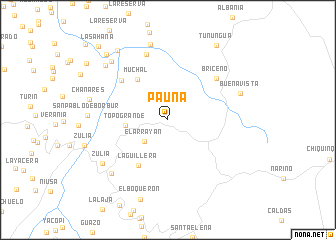
Pauna (Boyacá, Colombia)Pauna is a town in the Boyacá region of Colombia. An overview map of the region around Pauna is displayed below.
regional and 3d topo map of Pauna, Colombia ::
Pauna airports ::
The nearest airport is BOG - Bogota Eldorado Intl, located 107.4 km south of Pauna.
Other airports nearby include EJA - Barrancabermeja Yariguies (152.3 km north), MDE - Rio Negro Jose Maria Cordova (169.0 km west), VVC - Villavicencio Vanguardia (169.8 km south), OTU - Otu (170.1 km north west), Nearby towns ::
El Arrayán (3.6km south west) //
Topo Grande (4.7km west) //
Muchal (5.7km north west) //
La Guillera (6.1km south west) //
El Canal (6.8km north west) //
Briceño (7.1km north east) //
Amocal (7.7km north) //
Buenavista (8.5km east) //
Bejucal (8.7km north) //
Hoya Grande (8.7km south west) //
Zulia (8.8km south west) //
Chanares (9.0km west) //
La María (9.1km north west) //
Miaches (9.2km north west) //
El Palmar (9.6km north west) //
Tununguá (9.9km north east) //
Meseta (10.0km north west) //
La Sahana (11.2km north west) //
[all distances 'as the bird flies' and approximate] 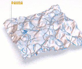 Places with similar names to Pauna, Colombia ::
Disclaimer :: Information on this page comes without warranty of any kind |
||
|
Where is Pauna? Elevation and coordinates ::
Latitude (lat): 5°39'31"N Longitude (lon): 73°58'57"W
Elevation (approx.): 1080m (map arrows pan, magnifying glasses zoom) |
||
|
Visiting Pauna? Hotel/Accommodation ::
Book a hotel in Pauna Travel Guide ::
Buy a travel guide for Colombia rental cars ::
car rental offers GPS waypoint ::
download a GPX waypoint (PoI) of Pauna for your GPS receiver
|
||