|
search place name
|
||
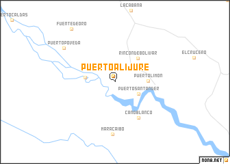
Puerto Alijure (Meta, Colombia)Puerto Alijure is a town in the Meta region of Colombia. An overview map of the region around Puerto Alijure is displayed below.
regional and 3d topo map of Puerto Alijure, Colombia ::
Puerto Alijure airports ::
The nearest airport is VVC - Villavicencio Vanguardia, located 87.3 km north of Puerto Alijure.
Other airports nearby include SJE - San Jose Del Guaviare Jorge E Gonzalez Torres (134.5 km south east), BOG - Bogota Eldorado Intl (160.4 km north west), SVI - San Vincente De Caguan Eduardo Falla Solano (191.8 km south west), NVA - Neiva Benito Salas (199.7 km west), Nearby towns ::
Puerto Santander (4.3km south east) //
La Cooperativa (4.9km west) //
Rincón de Bolívar (5.4km north east) //
Puerto Limón (5.4km east) //
Caño Blanco (7.0km south east) //
Maracaibo (8.6km south) //
Puerto Poveda (10.0km north west) //
Fuente de Oro (11.2km north west) //
[all distances 'as the bird flies' and approximate] 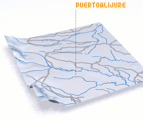 Places with similar names to Puerto Alijure, Colombia :: Disclaimer :: Information on this page comes without warranty of any kind |
||
|
Where is Puerto Alijure? Elevation and coordinates ::
Latitude (lat): 3°22'53"N Longitude (lon): 73°32'56"W
Elevation (approx.): 249m (map arrows pan, magnifying glasses zoom) |
||
|
Visiting Puerto Alijure? Hotel/Accommodation ::
Book a hotel in Puerto Alijure Travel Guide ::
Buy a travel guide for Colombia rental cars ::
car rental offers GPS waypoint ::
download a GPX waypoint (PoI) of Puerto Alijure for your GPS receiver
|
||