|
search place name
|
||
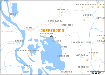
Puerto Rico (Magdalena, Colombia)Puerto Rico is a town in the Magdalena region of Colombia. An overview map of the region around Puerto Rico is displayed below.
regional and 3d topo map of Puerto Rico, Colombia ::
Puerto Rico airports ::
The nearest airport is MGN - Magangue Baracoa, located 55.5 km south of Puerto Rico.
Other airports nearby include CZU - Corozal Las Brujas (79.2 km south west), CTG - Cartagena Rafael Nunez (115.1 km north west), BAQ - Barranquilla Ernesto Cortissoz (124.2 km north), SMR - Santa Marta Simon Bolivar (158.5 km north), Nearby towns ::
Cerro Grande (0.8km east) //
Platanal (2.5km south east) //
Punta Gorda (2.6km west) //
Villa Calixta (5.0km north east) //
Campo Alegre (5.1km north) //
Zárate (5.8km south east) //
Aguas Vivas (6.1km east) //
Miraflores (6.1km north east) //
Susán (7.2km south east) //
Buenavista (8.5km south east) //
Cienagueta (8.6km north) //
Plato (8.6km west) //
Cuatro Vientos (10.7km south west) //
La Estación (10.8km north east) //
[all distances 'as the bird flies' and approximate]  Places with similar names to Puerto Rico, Colombia ::
// Pôrto Rico (BR)
// Pôrto Rico (BR)
// Porto Rico (PA)
// Pretarouca (PT)
// Priedrieki (LV)
// Pereterg (RU)
// Peretërki (RU)
// Puerto Rico (US)
// Puerto Rico (CL)
// Puerto Arquía (CO)
Disclaimer :: Information on this page comes without warranty of any kind |
||
|
Where is Puerto Rico? Elevation and coordinates ::
Latitude (lat): 9°46'6"N Longitude (lon): 74°42'45"W
Elevation (approx.): 9m (map arrows pan, magnifying glasses zoom) |
||
|
Visiting Puerto Rico? Hotel/Accommodation ::
Book a hotel in Puerto Rico Travel Guide ::
Buy a travel guide for Colombia rental cars ::
car rental offers GPS waypoint ::
download a GPX waypoint (PoI) of Puerto Rico for your GPS receiver
|
||