|
search place name
|
||
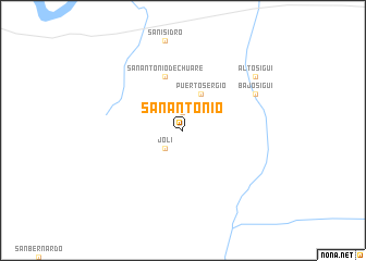
San Antonio (Cauca, Colombia)San Antonio is a town in the Cauca region of Colombia. An overview map of the region around San Antonio is displayed below.
regional and 3d topo map of San Antonio, Colombia ::
San Antonio airports ::
The nearest airport is GPI - Guapi Juan Casiano, located 77.8 km west of San Antonio.
Other airports nearby include PPN - Popayan Guillermo Leon Valencia (82.7 km south east), BUN - Buenaventura Gerardo Tobar Lopez (112.8 km north), CLO - Cali Alfonso Bonilla Aragon Intl (124.4 km north east), PSO - Pasto Antonio Narino (159.0 km south), Nearby towns ::
San Miguel (1.9km north) //
López (2.2km north) //
Jolí (2.6km south west) //
Alto Chuaré (4.1km north east) //
Puerto Sergio (4.1km north east) //
San Antonio de Chuaré (5.9km north) //
Bajo Sigüí (8.3km north east) //
Alto Sigüí (9.3km north east) //
[all distances 'as the bird flies' and approximate] 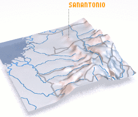 Places with similar names to San Antonio, Colombia ::
// San Antônio (BR)
// San Antonio (BZ)
// San Antonio (BZ)
// San Antonio (BZ)
// San Antonio (BZ)
// San Antonio (US)
// San Antonio (US)
// San Antonio (US)
// San Antonio (PA)
// San Antonio (PA)
Disclaimer :: Information on this page comes without warranty of any kind |
||
|
Where is San Antonio? Elevation and coordinates ::
Latitude (lat): 2°50'0"N Longitude (lon): 77°15'0"W
Elevation (approx.): 45m (map arrows pan, magnifying glasses zoom) |
||
|
Visiting San Antonio? Hotel/Accommodation ::
Book a hotel in San Antonio Travel Guide ::
Buy a travel guide for Colombia rental cars ::
car rental offers GPS waypoint ::
download a GPX waypoint (PoI) of San Antonio for your GPS receiver
|
||