|
search place name
|
||
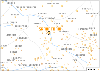
San Antonio (Valle del Cauca, Colombia)San Antonio is a town in the Valle del Cauca region of Colombia. An overview map of the region around San Antonio is displayed below.
regional and 3d topo map of San Antonio, Colombia ::
San Antonio airports ::
The nearest airport is AXM - Armenia El Eden, located 32.5 km north east of San Antonio.
Other airports nearby include ULQ - Tulua Farfan (35.6 km south west), PEI - Pereira Matecana (69.6 km north), CLO - Cali Alfonso Bonilla Aragon Intl (89.1 km south west), IBE - Ibague Perales (92.5 km east), Nearby towns ::
La Coqueta (1.2km south) //
La Camelia (1.4km north) //
Abrego Número Dos (1.6km north west) //
Mercedes (1.7km north west) //
La Floresta (1.7km south) //
Coloradas (1.8km west) //
Cominales (1.9km north east) //
Bellavista (2.0km north east) //
La Cabaña (2.0km north west) //
San Marcos (2.1km south west) //
Columbia (2.2km south west) //
Canoas (2.5km south) //
La Hacienda (2.6km south west) //
Santa Mónica (3.0km south) //
La Zulia (3.0km west) //
El Brillante (3.4km south west) //
Gibraltar (3.8km south west) //
San Martín (4.0km west) //
La Calera (4.5km south west) //
Pavas (4.5km north east) //
La Rivera (4.6km east) //
La Laguna (4.7km south) //
Juan XXIII (4.7km south west) //
La Cabaña (5.0km south east) //
Casa de Zinc (5.2km east) //
Norcasia (5.2km south) //
Altomira (5.5km south east) //
La Isla (5.6km north) //
Sevilla (5.8km north) //
[all distances 'as the bird flies' and approximate] 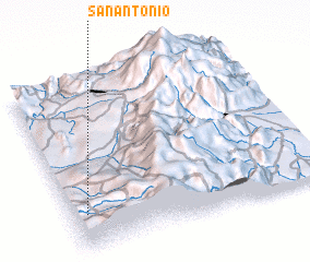 Places with similar names to San Antonio, Colombia ::
// San Antônio (BR)
// San Antonio (BZ)
// San Antonio (BZ)
// San Antonio (BZ)
// San Antonio (BZ)
// San Antonio (US)
// San Antonio (US)
// San Antonio (US)
// San Antonio (PA)
// San Antonio (PA)
Disclaimer :: Information on this page comes without warranty of any kind |
||
|
Where is San Antonio? Elevation and coordinates ::
Latitude (lat): 4°13'1"N Longitude (lon): 75°56'27"W
Elevation (approx.): 1508m (map arrows pan, magnifying glasses zoom) |
||
|
Visiting San Antonio? Hotel/Accommodation ::
Book a hotel in San Antonio Travel Guide ::
Buy a travel guide for Colombia rental cars ::
car rental offers GPS waypoint ::
download a GPX waypoint (PoI) of San Antonio for your GPS receiver
|
||