|
search place name
|
||
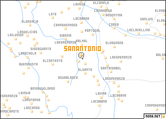
San Antonio (Santander, Colombia)San Antonio is a town in the Santander region of Colombia. An overview map of the region around San Antonio is displayed below.
regional and 3d topo map of San Antonio, Colombia ::
San Antonio airports ::
The nearest airport is EJA - Barrancabermeja Yariguies, located 32.8 km north of San Antonio.
Other airports nearby include BGA - Bucaramanga Palonegro (77.4 km north east), OTU - Otu (109.7 km west), OCV - Ocana Aguas Claras (180.7 km north), SVZ - San Antonio Del Tachira (190.8 km north east), Nearby towns ::
Villamo (1.0km south west) //
Fundación (1.1km south east) //
Si Dios Quiere (2.8km north) //
El Danto (3.2km south) //
Palmal (3.3km north) //
Potosí (4.3km north west) //
Villa de Leiva (4.5km south east) //
Santa Rosa (4.5km east) //
La Porfía (4.7km west) //
La Bodega (4.9km north east) //
La Esperanza (4.9km north west) //
La Estrella (5.1km east) //
Estación La Florida (5.8km east) //
Samaria (5.8km south east) //
Siberia (6.0km north west) //
Agua Blanca (6.0km south west) //
Portugal (6.0km north) //
La Palmita (6.3km north) //
La Esmeralda (6.7km south east) //
El Contento (6.9km west) //
Santa Isabel (7.0km south east) //
El Madroño (7.6km east) //
Campo Hermoso (8.0km north west) //
La Cabaña (8.3km north) //
La Esperanza (8.5km east) //
La Esperanza (8.7km south east) //
La Viña (9.5km south east) //
Corea (9.9km north east) //
Campo Alicias (10.0km south east) //
[all distances 'as the bird flies' and approximate]  Places with similar names to San Antonio, Colombia ::
// San Antônio (BR)
// San Antonio (BZ)
// San Antonio (BZ)
// San Antonio (BZ)
// San Antonio (BZ)
// San Antonio (US)
// San Antonio (US)
// San Antonio (US)
// San Antonio (PA)
// San Antonio (PA)
Disclaimer :: Information on this page comes without warranty of any kind |
||
|
Where is San Antonio? Elevation and coordinates ::
Latitude (lat): 6°43'53"N Longitude (lon): 73°45'47"W
Elevation (approx.): 132m (map arrows pan, magnifying glasses zoom) |
||
|
Visiting San Antonio? Hotel/Accommodation ::
Book a hotel in San Antonio Travel Guide ::
Buy a travel guide for Colombia rental cars ::
car rental offers GPS waypoint ::
download a GPX waypoint (PoI) of San Antonio for your GPS receiver
|
||