|
search place name
|
||
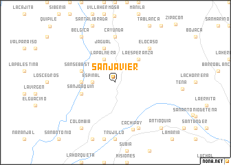
San Javier (Cundinamarca, Colombia)San Javier is a town in the Cundinamarca region of Colombia. An overview map of the region around San Javier is displayed below.
regional and 3d topo map of San Javier, Colombia ::
San Javier airports ::
The nearest airport is BOG - Bogota Eldorado Intl, located 35.7 km east of San Javier.
Other airports nearby include IBE - Ibague Perales (78.8 km west), VVC - Villavicencio Vanguardia (109.6 km south east), MZL - Manizales La Nubia (117.8 km west), PEI - Pereira Matecana (142.1 km west), Nearby towns ::
Espinal (3.7km west) //
San Roque (3.7km west) //
La Palmera (4.1km north west) //
La Esperanza (5.2km north east) //
Baltimore (5.5km west) //
Manzanares (5.8km west) //
La Vega (5.8km west) //
San Sebastián (5.8km west) //
Jagual (5.9km north) //
San Joaquín (5.8km west) //
Cayunda (7.4km north) //
El Ocaso (7.8km north east) //
Cachipay (8.1km south) //
Betulia (8.3km south east) //
Bélgica (9.3km north west) //
Colombia (9.3km south west) //
Antioquia (10.5km south east) //
[all distances 'as the bird flies' and approximate] 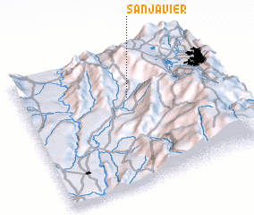 Places with similar names to San Javier, Colombia ::
// San Javier (PA)
// San Javier (ES)
// San Javier (CL)
// San Javier (CL)
// San Javier (CL)
// San Javier (CL)
// San Javier (CL)
// San Javier (CO)
// San Javier (CO)
// San Javier (CO)
Disclaimer :: Information on this page comes without warranty of any kind |
||
|
Where is San Javier? Elevation and coordinates ::
Latitude (lat): 4°40'0"N Longitude (lon): 74°28'0"W
Elevation (approx.): 878m (map arrows pan, magnifying glasses zoom) |
||
|
Visiting San Javier? Hotel/Accommodation ::
Book a hotel in San Javier Travel Guide ::
Buy a travel guide for Colombia rental cars ::
car rental offers GPS waypoint ::
download a GPX waypoint (PoI) of San Javier for your GPS receiver
|
||