|
search place name
|
||
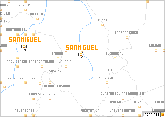
San Miguel (Cundinamarca, Colombia)San Miguel is a town in the Cundinamarca region of Colombia. An overview map of the region around San Miguel is displayed below.
regional and 3d topo map of San Miguel, Colombia ::
San Miguel airports ::
The nearest airport is BOG - Bogota Eldorado Intl, located 36.7 km south east of San Miguel.
Other airports nearby include IBE - Ibague Perales (100.6 km south west), VVC - Villavicencio Vanguardia (120.2 km south east), MZL - Manizales La Nubia (120.4 km west), PEI - Pereira Matecana (151.0 km west), Nearby towns ::
San Antonio (1.9km north) //
La María (4.1km south west) //
Guane (4.1km north west) //
Taboga (5.5km west) //
El Dorán (6.7km south west) //
El Dintel (6.7km south east) //
Sasaima (7.1km south west) //
El Chuscal (7.4km east) //
Mancilla (7.8km south east) //
Los Andes (8.3km south west) //
San Pedro (8.3km south west) //
La Frontera (8.3km south west) //
La Vega (8.9km north east) //
Nazaret (9.2km south west) //
Albán (10.5km south west) //
[all distances 'as the bird flies' and approximate] 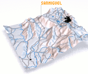 Places with similar names to San Miguel, Colombia ::
// San Miguel (BZ)
// San Miguel (BZ)
// San Miguel (US)
// San Miguel (US)
// San Miguel (US)
// San Miguel (US)
// San Miguel (US)
// San Miguel (PA)
// San Miguel (PA)
// San Miguel (PA)
Disclaimer :: Information on this page comes without warranty of any kind |
||
|
Where is San Miguel? Elevation and coordinates ::
Latitude (lat): 4°56'0"N Longitude (lon): 74°23'0"W
Elevation (approx.): 1579m (map arrows pan, magnifying glasses zoom) |
||
|
Visiting San Miguel? Hotel/Accommodation ::
Book a hotel in San Miguel Travel Guide ::
Buy a travel guide for Colombia rental cars ::
car rental offers GPS waypoint ::
download a GPX waypoint (PoI) of San Miguel for your GPS receiver
|
||