|
search place name
|
||
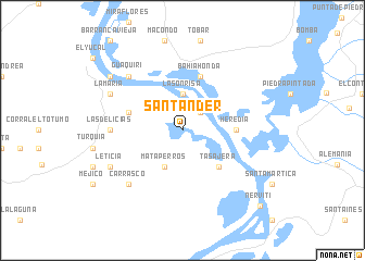
Santander (Bolívar, Colombia)Santander is a town in the Bolívar region of Colombia. An overview map of the region around Santander is displayed below.
regional and 3d topo map of Santander, Colombia ::
Santander airports ::
The nearest airport is CTG - Cartagena Rafael Nunez, located 82.1 km north west of Santander.
Other airports nearby include MGN - Magangue Baracoa (86.5 km south), BAQ - Barranquilla Ernesto Cortissoz (91.5 km north), CZU - Corozal Las Brujas (93.3 km south west), SMR - Santa Marta Simon Bolivar (135.7 km north east), Nearby towns ::
Robles (2.6km north east) //
La Sonrisa (3.7km north) //
Mataperros (4.1km south west) //
Tasajera (5.2km south east) //
Heredia (5.5km east) //
El Limón (5.8km west) //
Bahía Honda (5.9km north) //
La Enea (7.3km west) //
Las Delicias (7.3km west) //
Guaquirí (7.8km north west) //
Carrasco (7.8km south west) //
La María (8.2km north west) //
Leticia (8.2km south west) //
Bodega de Buenavista (9.2km north west) //
Nervití (11.1km south east) //
[all distances 'as the bird flies' and approximate] 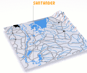 Places with similar names to Santander, Colombia ::
// Santana do Ouro (BR)
// Santo André (BR)
// Santo André (BR)
// Santo André (BR)
// Santo André (BR)
// Santo André (BR)
// Santo André (BR)
// Santo André (BR)
// Santo André (BR)
// Saint Andrew (US)
Disclaimer :: Information on this page comes without warranty of any kind |
||
|
Where is Santander? Elevation and coordinates ::
Latitude (lat): 10°4'0"N Longitude (lon): 74°52'0"W
Elevation (approx.): 10m (map arrows pan, magnifying glasses zoom) |
||
|
Visiting Santander? Hotel/Accommodation ::
Book a hotel in Santander Travel Guide ::
Buy a travel guide for Colombia rental cars ::
car rental offers GPS waypoint ::
download a GPX waypoint (PoI) of Santander for your GPS receiver
|
||