|
search place name
|
||
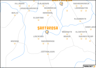
Santa Rosa (Córdoba, Colombia)Santa Rosa is a town in the Córdoba region of Colombia. An overview map of the region around Santa Rosa is displayed below.
regional and 3d topo map of Santa Rosa, Colombia ::
Santa Rosa airports ::
The nearest airport is MTR - Monteria Los Garzones, located 66.9 km north of Santa Rosa.
Other airports nearby include CZU - Corozal Las Brujas (125.7 km north), MGN - Magangue Baracoa (143.5 km north east), OTU - Otu (170.4 km south east), EJA - Barrancabermeja Yariguies (242.9 km south east), Nearby towns ::
Nuevo Paraíso (3.7km south) //
Calle Barrida (4.1km south west) //
El Naranjo (4.1km north west) //
Los Cacaos (4.1km south west) //
El Guayabo (6.7km north west) //
Bodeguita (7.3km east) //
Marañonal (7.4km north) //
Bodega (7.6km east) //
Centro Alegre (7.9km south) //
[all distances 'as the bird flies' and approximate] 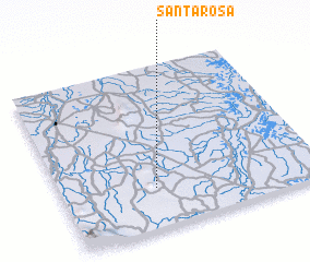 Places with similar names to Santa Rosa, Colombia ::
// Sania Torres (MA)
// Santa Rosa (BR)
// Santa Rosa (BR)
// Santa Rosa (BR)
// Santa Rosa (BR)
// Santa Rosa (BR)
// Santa Rosa (BR)
// Santa Rosa (BR)
// Santa Rosa (BR)
// Santa Rosa (BR)
Disclaimer :: Information on this page comes without warranty of any kind |
||
|
Where is Santa Rosa? Elevation and coordinates ::
Latitude (lat): 8°15'0"N Longitude (lon): 75°38'0"W
Elevation (approx.): 65m (map arrows pan, magnifying glasses zoom) |
||
|
Visiting Santa Rosa? Hotel/Accommodation ::
Book a hotel in Santa Rosa Travel Guide ::
Buy a travel guide for Colombia rental cars ::
car rental offers GPS waypoint ::
download a GPX waypoint (PoI) of Santa Rosa for your GPS receiver
|
||