|
search place name
|
||
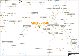
Santa Rosa (Cundinamarca, Colombia)Santa Rosa is a town in the Cundinamarca region of Colombia. An overview map of the region around Santa Rosa is displayed below.
regional and 3d topo map of Santa Rosa, Colombia ::
Santa Rosa airports ::
The nearest airport is BOG - Bogota Eldorado Intl, located 49.9 km west of Santa Rosa.
Other airports nearby include VVC - Villavicencio Vanguardia (70.3 km south), IBE - Ibague Perales (163.6 km west), MZL - Manizales La Nubia (196.6 km west), MDE - Rio Negro Jose Maria Cordova (242.9 km north west), Nearby towns ::
Sueva (1.4km north) //
El Centro (1.4km south west) //
Nemostén (2.1km west) //
San José (2.4km north east) //
Valle Deptal (2.4km south east) //
El Carmen (2.5km north west) //
Valle (2.5km south east) //
La Vega (3.0km north east) //
San Pedro (3.2km east) //
Alemania (3.6km south east) //
El Zaque (4.5km north east) //
San Roque (5.1km north east) //
Los Andes (5.9km west) //
Cárpatos (5.9km west) //
San Gregorio (6.2km north east) //
Santa Bárbara (6.4km east) //
El Amoladaro (7.0km north west) //
Yonama (7.1km north east) //
Cuzaquin (7.1km north east) //
El Chital (7.2km north west) //
Volcán Negro (7.2km south east) //
Los Arrayanes (7.2km north east) //
El Desierto (7.6km north east) //
Junín (7.6km east) //
La Chamba (7.7km north east) //
Gachetá (7.9km east) //
Palmar (8.1km north west) //
Gachetá (8.3km east) //
Las Salinas (8.7km north east) //
[all distances 'as the bird flies' and approximate] 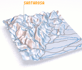 Places with similar names to Santa Rosa, Colombia ::
// Sania Torres (MA)
// Santa Rosa (BR)
// Santa Rosa (BR)
// Santa Rosa (BR)
// Santa Rosa (BR)
// Santa Rosa (BR)
// Santa Rosa (BR)
// Santa Rosa (BR)
// Santa Rosa (BR)
// Santa Rosa (BR)
Disclaimer :: Information on this page comes without warranty of any kind |
||
|
Where is Santa Rosa? Elevation and coordinates ::
Latitude (lat): 4°47'48"N Longitude (lon): 73°42'27"W
Elevation (approx.): 2137m (map arrows pan, magnifying glasses zoom) |
||
|
Visiting Santa Rosa? Hotel/Accommodation ::
Book a hotel in Santa Rosa Travel Guide ::
Buy a travel guide for Colombia rental cars ::
car rental offers GPS waypoint ::
download a GPX waypoint (PoI) of Santa Rosa for your GPS receiver
|
||