|
search place name
|
||
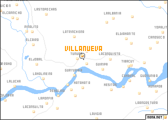
Villanueva (Departamento de Casanare, Colombia)Villanueva is a town in the Departamento de Casanare region of Colombia. An overview map of the region around Villanueva is displayed below.
regional and 3d topo map of Villanueva, Colombia ::
Villanueva airports ::
The nearest airport is VVC - Villavicencio Vanguardia, located 120.4 km west of Villanueva.
Other airports nearby include BOG - Bogota Eldorado Intl (181.5 km west), SJE - San Jose Del Guaviare Jorge E Gonzalez Torres (197.5 km south), Nearby towns ::
El Brazo (1.0km south east) //
Tunupe (1.5km west) //
La Palmita (2.1km north) //
Guayuriba (4.0km south west) //
Güiripa (4.6km south east) //
Güirripa (4.6km south east) //
La Trinchera (5.7km north west) //
La Conquista (5.8km east) //
Matamata (6.2km south) //
Las Moritas (6.7km south west) //
La Florida (7.2km south west) //
Piedra Candela (8.2km south) //
Mesitas (9.0km south east) //
La Porfía (9.8km north east) //
Remolino (9.9km south west) //
Puerto Guadalupe (10.6km south east) //
[all distances 'as the bird flies' and approximate] 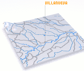 Places with similar names to Villanueva, Colombia ::
// Val'nëvo (RU)
// Villa Nueva (BO)
// Villa Nueva (BO)
// Villa Nueva (BO)
// Volynovo (RU)
// Vila Nova (PT)
// Vila Nova (PT)
// Vila Nova (PT)
// Vila Nova (PT)
// Vila Nova (PT)
Disclaimer :: Information on this page comes without warranty of any kind |
||
|
Where is Villanueva? Elevation and coordinates ::
Latitude (lat): 4°21'49"N Longitude (lon): 72°32'48"W
Elevation (approx.): 165m (map arrows pan, magnifying glasses zoom) |
||
|
Visiting Villanueva? Hotel/Accommodation ::
Book a hotel in Villanueva Travel Guide ::
Buy a travel guide for Colombia rental cars ::
car rental offers GPS waypoint ::
download a GPX waypoint (PoI) of Villanueva for your GPS receiver
|
||