|
search place name
|
||
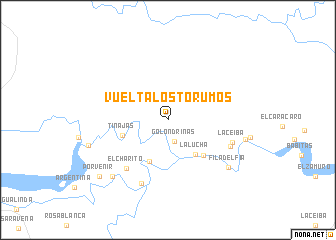
Vuelta Los Torumos (Departamento de Arauca, Colombia)Vuelta Los Torumos is a town in the Departamento de Arauca region of Colombia. An overview map of the region around Vuelta Los Torumos is displayed below.
regional and 3d topo map of Vuelta Los Torumos, Colombia ::
Vuelta Los Torumos airports ::
The nearest airport is STD - Santo Domingo Mayor Buenaventura Vivas, located 63.9 km north west of Vuelta Los Torumos.
Other airports nearby include TME - Tame (68.9 km south), AUC - Arauca Santiago Perez (109.9 km east), SVZ - San Antonio Del Tachira (115.4 km north west), CUC - Cucuta Camilo Daza (127.8 km north west), Nearby towns ::
Golondrinas (2.5km south) //
La Lucha (4.9km south east) //
Rosentalla (5.1km south west) //
Tinajas (5.4km west) //
Puerto Lleras (5.7km south east) //
El Charito (7.2km south west) //
Cascarón (7.6km south east) //
La Ceiba (7.6km east) //
Panamá (7.7km south west) //
Filadelfia (8.5km south east) //
Puerto Niño (8.8km south west) //
Isla Burrigui (8.9km east) //
La Rompida (9.2km west) //
Porvenir (9.9km south west) //
[all distances 'as the bird flies' and approximate] 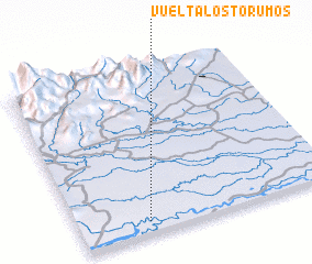 Places with similar names to Vuelta Los Torumos, Colombia :: Disclaimer :: Information on this page comes without warranty of any kind |
||
|
Where is Vuelta Los Torumos? Elevation and coordinates ::
Latitude (lat): 7°4'23"N Longitude (lon): 71°43'53"W
Elevation (approx.): 180m (map arrows pan, magnifying glasses zoom) |
||
|
Visiting Vuelta Los Torumos? Hotel/Accommodation ::
Book a hotel in Vuelta Los Torumos Travel Guide ::
Buy a travel guide for Colombia rental cars ::
car rental offers GPS waypoint ::
download a GPX waypoint (PoI) of Vuelta Los Torumos for your GPS receiver
|
||