|
search place name
|
||
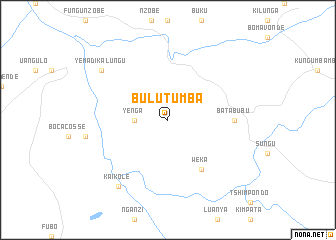
Bulu-Tumba (Congo, Democratic Republic of the)Bulu-Tumba is a town in Congo, Democratic Republic of the. An overview map of the region around Bulu-Tumba is displayed below.
regional and 3d topo map of Bulu-Tumba, Congo, Democratic Republic of the ::
Bulu-Tumba airports ::
The nearest airport is CAB - Cabinda, located 63.4 km south west of Bulu-Tumba.
Other airports nearby include MNB - Muanda (84.3 km south), PNR - Pointe-noire Pointe Noire (92.3 km north west), SZA - Soyo (105.8 km south), SSY - M'banza-congo Mbanza Congo (214.9 km south east), Nearby towns ::
Yenga (3.7km west) //
Weka (6.7km south east) //
Bata-Bubu (7.4km east) //
Kai-Kole (9.3km south west) //
Yema-di-Kalungu (9.2km north west) //
[all distances 'as the bird flies' and approximate] 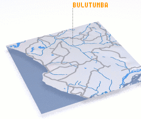 Places with similar names to Bulu-Tumba, Congo, Democratic Republic of the ::
// Bültum (DE)
// Blue Dome (US)
// Balṭîm (EG)
// Bāldameh (IR)
// Belo-Dumbu (CD)
// Boulotombi (CG)
// Bultumbay (KZ)
// Boultoum (NE)
// Bilatum (NG)
// Buladiama (NG)
Disclaimer :: Information on this page comes without warranty of any kind |
||
|
Where is Bulu-Tumba? Elevation and coordinates ::
Latitude (lat): 5°13'0"S Longitude (lon): 12°37'0"E
Elevation (approx.): 135m (map arrows pan, magnifying glasses zoom) |
||
|
Visiting Bulu-Tumba? Hotel/Accommodation ::
Book a hotel in Bulu-Tumba Travel Guide ::
rental cars ::
car rental offers GPS waypoint ::
download a GPX waypoint (PoI) of Bulu-Tumba for your GPS receiver
|
||