|
search place name
|
||
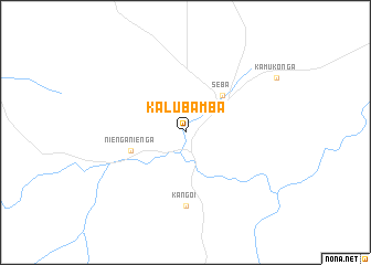
Kalubamba (Congo, Democratic Republic of the)Kalubamba is a town in Congo, Democratic Republic of the. An overview map of the region around Kalubamba is displayed below.
regional and 3d topo map of Kalubamba, Congo, Democratic Republic of the ::
Kalubamba airports ::
The nearest airport is KWZ - Kolwezi, located 93.3 km south of Kalubamba.
Other airports nearby include KMN - Kamina Base (143.4 km north), Nearby towns ::
Munanga (5.2km north east) //
Seba (5.2km north east) //
Nienga-Nienga (5.8km west) //
Kangoi (7.4km south) //
[all distances 'as the bird flies' and approximate]  Places with similar names to Kalubamba, Congo, Democratic Republic of the ::
// Calubaima (CO)
// Guaillabamba (EC)
// Guaillabamba (EC)
// Guaillabamba (EC)
// Guayllabamba (EC)
// Golbūm (IR)
// Quillabamba (PE)
// Kollé Bamba (GN)
// Kilibiama (NG)
// Kolbami (KR)
Disclaimer :: Information on this page comes without warranty of any kind |
||
|
Where is Kalubamba? Elevation and coordinates ::
Latitude (lat): 9°56'0"S Longitude (lon): 25°22'0"E
Elevation (approx.): 865m (map arrows pan, magnifying glasses zoom) |
||
|
Visiting Kalubamba? Hotel/Accommodation ::
Book a hotel in Kalubamba Travel Guide ::
rental cars ::
car rental offers GPS waypoint ::
download a GPX waypoint (PoI) of Kalubamba for your GPS receiver
|
||