|
search place name
|
||
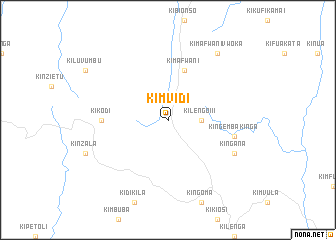
Kimvidi (Congo, Democratic Republic of the)Kimvidi is a town in Congo, Democratic Republic of the. An overview map of the region around Kimvidi is displayed below.
regional and 3d topo map of Kimvidi, Congo, Democratic Republic of the ::
Kimvidi airports ::
The nearest airport is FIH - Kinshasa Ndjili Intl, located 147.4 km north of Kimvidi.
Other airports nearby include NLO - Kinshasa Ndolo (158.1 km north), BZV - Brazzaville Maya Maya (168.9 km north west), SSY - M'banza-congo Mbanza Congo (192.0 km west), UGO - Uige (235.1 km south west), Nearby towns ::
Kilengo III (3.7km east) //
Kimafwani (5.9km north) //
Kikodi (7.4km west) //
Kingemba-Kinga (7.6km east) //
Kingana (8.3km south east) //
Kimafwani-Vwoka (9.3km north east) //
[all distances 'as the bird flies' and approximate]  Places with similar names to Kimvidi, Congo, Democratic Republic of the ::
// Camp Hayt (PH)
// Ga-Mafate (ZA)
// Ga-Maphoto (ZA)
// Ga-Maphoto (ZA)
// Gamba-Fioti (CD)
// Kimfoutou (CG)
// Kāmvādi (IN)
// Kamphata (ZM)
// Cam Fat (VN)
// Kim Phat (VN)
Disclaimer :: Information on this page comes without warranty of any kind |
||
|
Where is Kimvidi? Elevation and coordinates ::
Latitude (lat): 5°39'0"S Longitude (lon): 15°52'0"E
Elevation (approx.): 857m (map arrows pan, magnifying glasses zoom) |
||
|
Visiting Kimvidi? Hotel/Accommodation ::
Book a hotel in Kimvidi Travel Guide ::
rental cars ::
car rental offers GPS waypoint ::
download a GPX waypoint (PoI) of Kimvidi for your GPS receiver
|
||