|
search place name
|
||
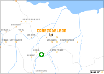
Cabeza de León (Alajuela, Costa Rica)Cabeza de León is a town in the Alajuela region of Costa Rica. An overview map of the region around Cabeza de León is displayed below.
regional and 3d topo map of Cabeza de León, Costa Rica ::
Cabeza de León airports ::
The nearest airport is LIR - Liberia Daniel Oduber Quiros Intl, located 73.0 km south west of Cabeza de León.
Other airports nearby include NOB - Nosara Beach Nosara (130.3 km south west), SJO - San Jose Juan Santamaria Intl (135.6 km south east), BEF - Bluefields (175.1 km north east), MGA - Managua Intl (184.6 km north west), Nearby towns ::
San Antonio (1.8km east) //
San Judas (1.9km south) //
La Cruz (1.8km west) //
San Isidro (2.6km south east) //
Montecristo (5.9km south) //
Casa Quemada (5.8km east) //
Delicias (7.3km west) //
Upala (7.8km south west) //
Valle Guadalupe (9.2km north west) //
Rosario (10.4km south west) //
[all distances 'as the bird flies' and approximate]  Places with similar names to Cabeza de León, Costa Rica :: Disclaimer :: Information on this page comes without warranty of any kind |
||
|
Where is Cabeza de León? Elevation and coordinates ::
Latitude (lat): 10°57'0"N Longitude (lon): 84°59'0"W
Elevation (approx.): 40m (map arrows pan, magnifying glasses zoom) |
||
|
Visiting Cabeza de León? Hotel/Accommodation ::
Book a hotel in Cabeza de León Travel Guide ::
Buy a travel guide for Costa Rica rental cars ::
car rental offers GPS waypoint ::
download a GPX waypoint (PoI) of Cabeza de León for your GPS receiver
|
||