|
search place name
|
||
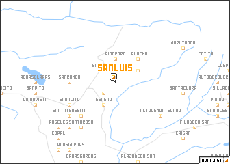
San Luis (Puntarenas, Costa Rica)San Luis is a town in the Puntarenas region of Costa Rica. An overview map of the region around San Luis is displayed below.
regional and 3d topo map of San Luis, Costa Rica ::
San Luis airports ::
The nearest airport is OTR - Coto 47, located 30.4 km south west of San Luis.
Other airports nearby include GLF - Golfito (42.4 km south west), DAV - David Enrique Malek Intl (68.3 km south east), PMZ - Palmar Sur (68.9 km west), CHX - Changuinola Cap Manuel Nino Intl (76.6 km north east), Nearby towns ::
San Miguel (2.6km north west) //
La Unión (2.6km south west) //
Río Negro (3.7km north) //
San Francisco (4.1km north east) //
Río Sereno (4.1km south west) //
Sereno (4.1km south west) //
La Lucha (5.2km north east) //
San Ramón (7.3km west) //
San Marcos (7.8km south west) //
Sabalito (8.2km south west) //
Santa Teresita (9.2km south west) //
Alto de Monte Lirio (9.2km south east) //
Santa Rosa (9.2km south west) //
San Antonio (10.4km south west) //
[all distances 'as the bird flies' and approximate] 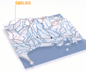 Places with similar names to San Luis, Costa Rica ::
Disclaimer :: Information on this page comes without warranty of any kind |
||
|
Where is San Luis? Elevation and coordinates ::
Latitude (lat): 8°51'0"N Longitude (lon): 82°51'0"W
Elevation (approx.): 1044m (map arrows pan, magnifying glasses zoom) |
||
|
Visiting San Luis? Hotel/Accommodation ::
Book a hotel in San Luis Travel Guide ::
Buy a travel guide for Costa Rica rental cars ::
car rental offers GPS waypoint ::
download a GPX waypoint (PoI) of San Luis for your GPS receiver
|
||