|
search place name
|
||
Santa Teresa (Cartago, Costa Rica)Santa Teresa is a town in the Cartago region of Costa Rica. An overview map of the region around Santa Teresa is displayed below.
regional and 3d topo map of Santa Teresa, Costa Rica ::

Santa Teresa airports ::
The nearest airport is SJO - San Jose Juan Santamaria Intl, located 47.1 km west of Santa Teresa.
Other airports nearby include XQP - Quepos La Managua (66.2 km south west), LIO - Limon Intl (83.5 km east), PMZ - Palmar Sur (114.0 km south), CHX - Changuinola Cap Manuel Nino Intl (148.6 km east), Nearby towns ::
Capellades (1.9km south) //
Coliblanco (1.9km north) //
Durán (2.6km south east) //
Pacayas (2.6km south west) //
Birrís (3.7km south) //
Quebrada Honda (3.7km south) //
Plantón (3.7km west) //
Sitio (4.1km south east) //
Naranjo (4.1km south east) //
Descanso (4.1km south west) //
Coliblanco (4.1km north west) //
Juan Viñas (5.2km south east) //
Trinidad (5.2km north east) //
La Pastora (5.2km north east) //
Pascón (5.2km south west) //
Sitio (5.5km east) //
Mesas (5.6km south) //
Esmeralda (5.8km east) //
Platanillal (5.8km west) //
San Martín (5.8km west) //
Cervantes (5.9km south) //
Mata de Guineo (5.9km south) //
Esperanza (5.9km north) //
Infiernillo (6.7km south east) //
Victoria (6.6km south east) //
Raicero (6.7km north east) //
Aguas (6.6km south west) //
Oratorio (6.6km south west) //
Santa Cruz (6.6km north east) //
[all distances 'as the bird flies' and approximate] 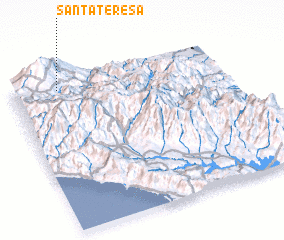 Places with similar names to Santa Teresa, Costa Rica ::
// Santa Teresa (BR)
// Santa Teresa (BR)
// Santa Teresa (BR)
// Santa Teresa (BR)
// Santa Teresa (BR)
// Santa Teresa (BR)
// Santa Teresa (BR)
// Santa Teresa (BR)
// Santa Teresa (BR)
// Santa Teresa (BR)
Disclaimer :: Information on this page comes without warranty of any kind |
||
|
Where is Santa Teresa? Elevation and coordinates ::
Latitude (lat): 9°56'0"N Longitude (lon): 83°47'0"W
Elevation (approx.): 1828m (map arrows pan, magnifying glasses zoom) |
||
|
Visiting Santa Teresa? Hotel/Accommodation ::
Book a hotel in Santa Teresa Travel Guide ::
Buy a travel guide for Costa Rica rental cars ::
car rental offers GPS waypoint ::
download a GPX waypoint (PoI) of Santa Teresa for your GPS receiver
|
||