|
search place name
|
||
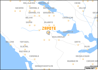
Zapote (San José, Costa Rica)Zapote is a town in the San José region of Costa Rica. An overview map of the region around Zapote is displayed below.
regional and 3d topo map of Zapote, Costa Rica ::
Zapote airports ::
The nearest airport is PMZ - Palmar Sur, located 22.9 km south east of Zapote.
Other airports nearby include GLF - Golfito (67.9 km south east), XQP - Quepos La Managua (70.7 km north west), OTR - Coto 47 (88.2 km south east), LIO - Limon Intl (109.1 km north east), Nearby towns ::
Guadalupe (1.9km south) //
Trinidad (2.6km south west) //
Pejibaye (3.7km north) //
Desamparados (4.1km north west) //
Águila Abajo (4.1km south east) //
Gibre (4.1km north east) //
San Miguel (6.6km north west) //
San Gabriel (7.4km north) //
San Martín (7.3km east) //
San Antonio (7.6km north) //
Sierra (8.2km north west) //
Mesas (8.3km north west) //
Bolivia (9.2km north west) //
San Pablito (9.2km north west) //
China Kichá (9.2km north east) //
[all distances 'as the bird flies' and approximate] 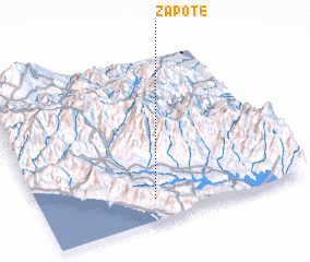 Places with similar names to Zapote, Costa Rica ::
Disclaimer :: Information on this page comes without warranty of any kind |
||
|
Where is Zapote? Elevation and coordinates ::
Latitude (lat): 9°8'0"N Longitude (lon): 83°34'0"W
Elevation (approx.): 700m (map arrows pan, magnifying glasses zoom) |
||
|
Visiting Zapote? Hotel/Accommodation ::
Book a hotel in Zapote Travel Guide ::
Buy a travel guide for Costa Rica rental cars ::
car rental offers GPS waypoint ::
download a GPX waypoint (PoI) of Zapote for your GPS receiver
|
||