|
search place name
|
||
Cañaveral de Afuera (Los Ríos, Ecuador)Cañaveral de Afuera is a town in the Los Ríos region of Ecuador. An overview map of the region around Cañaveral de Afuera is displayed below.
regional and 3d topo map of Cañaveral de Afuera, Ecuador ::

Cañaveral de Afuera airports ::
The nearest airport is GYE - Guayaquil Jose Joaquin De Olmedo Intl, located 64.7 km south west of Cañaveral de Afuera.
Other airports nearby include ATF - Ambato Chachoan (116.4 km north east), PVO - Portoviejo Reales Tamarindos (134.0 km north west), CUE - Cuenca Mariscal Lamar (139.4 km south east), MEC - Manta Eloy Alfaro Intl (159.0 km north west), Nearby towns ::
Bella Vista (3.7km east) //
Manila (4.1km north west) //
Vainilla (5.9km east) //
La Unión (5.9km south) //
La Clementina (6.7km south east) //
Playas (6.7km north east) //
Cañaveral (6.7km north east) //
La Victoria (6.7km north west) //
Julia (6.7km north west) //
Barreiro (6.7km south west) //
Merella (7.9km north east) //
Corozal (8.3km north west) //
La María (9.3km north east) //
Caracol (9.3km north east) //
Pozuelos (9.3km north east) //
[all distances 'as the bird flies' and approximate] 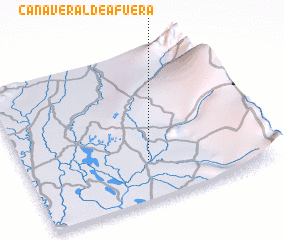 Places with similar names to Cañaveral de Afuera, Ecuador :: Disclaimer :: Information on this page comes without warranty of any kind |
||
|
Where is Cañaveral de Afuera? Elevation and coordinates ::
Latitude (lat): 1°44'0"S Longitude (lon): 79°29'0"W
Elevation (approx.): 11m (map arrows pan, magnifying glasses zoom) |
||
|
Visiting Cañaveral de Afuera? Hotel/Accommodation ::
Book a hotel in Cañaveral de Afuera Travel Guide ::
Buy a travel guide for Ecuador rental cars ::
car rental offers GPS waypoint ::
download a GPX waypoint (PoI) of Cañaveral de Afuera for your GPS receiver
|
||