|
search place name
|
||
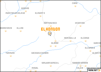
El Hondón (Loja, Ecuador)El Hondón is a town in the Loja region of Ecuador. An overview map of the region around El Hondón is displayed below.
regional and 3d topo map of El Hondón, Ecuador ::
El Hondón airports ::
The nearest airport is TBP - Tumbes Pedro Canga, located 61.7 km north west of El Hondón.
Other airports nearby include MCH - Machala General Manuel Serrano (81.4 km north), PIU - Piura Capitan Fap Guillermo Concha Iberico (147.4 km south west), TYL - Talara Capitan Montes (148.1 km south west), CUE - Cuenca Mariscal Lamar (170.6 km north east), Nearby towns ::
Buenos Aires (2.6km north west) //
El Ciénego (2.6km south east) //
Montehuaico (3.7km north) //
Chaquinal (3.7km south) //
Alamor (4.1km south east) //
Hacienda El Laurel (4.1km south east) //
Mercadillo (7.6km east) //
El Puente (8.3km north west) //
Doce de Diciembre (8.3km south west) //
[all distances 'as the bird flies' and approximate] 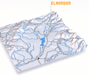 Places with similar names to El Hondón, Ecuador ::
// El Hondón (CU)
Disclaimer :: Information on this page comes without warranty of any kind |
||
|
Where is El Hondón? Elevation and coordinates ::
Latitude (lat): 4°0'0"S Longitude (lon): 80°3'0"W
Elevation (approx.): 848m (map arrows pan, magnifying glasses zoom) |
||
|
Visiting El Hondón? Hotel/Accommodation ::
Book a hotel in El Hondón Travel Guide ::
Buy a travel guide for Ecuador rental cars ::
car rental offers GPS waypoint ::
download a GPX waypoint (PoI) of El Hondón for your GPS receiver
|
||