|
search place name
|
||
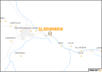
Gloria María (Pichincha, Ecuador)Gloria María is a town in the Pichincha region of Ecuador. An overview map of the region around Gloria María is displayed below.
regional and 3d topo map of Gloria María, Ecuador ::
Gloria María airports ::
The nearest airport is UIO - Quito Mariscal Sucre Intl, located 67.7 km east of Gloria María.
Other airports nearby include ATF - Ambato Chachoan (118.9 km south east), PVO - Portoviejo Reales Tamarindos (176.8 km south west), MEC - Manta Eloy Alfaro Intl (192.8 km south west), TUA - Tulcan Teniente Coronel Luis A Mantilla (193.9 km north east), Nearby towns ::
Guadalupe (0.0km north) //
María Teresa (1.9km west) //
Chiguilpe (1.9km west) //
Villa Aidita (1.9km west) //
La Zarumeña (4.1km north west) //
La Grimpola (4.1km north west) //
La Primavera (4.1km north west) //
Paquimaro (4.1km north west) //
Santa Inés (4.1km north west) //
La Estancia (5.2km south east) //
Tanti (5.2km south east) //
El Porvenir (5.9km west) //
Borneo (5.9km west) //
Santo Domingo de los Colorados (7.6km west) //
Lelia (8.3km south east) //
[all distances 'as the bird flies' and approximate]  Places with similar names to Gloria María, Ecuador ::
Disclaimer :: Information on this page comes without warranty of any kind |
||
|
Where is Gloria María? Elevation and coordinates ::
Latitude (lat): 0°16'0"S Longitude (lon): 79°5'0"W
Elevation (approx.): 578m (map arrows pan, magnifying glasses zoom) |
||
|
Visiting Gloria María? Hotel/Accommodation ::
Book a hotel in Gloria María Travel Guide ::
Buy a travel guide for Ecuador rental cars ::
car rental offers GPS waypoint ::
download a GPX waypoint (PoI) of Gloria María for your GPS receiver
|
||