|
search place name
|
||
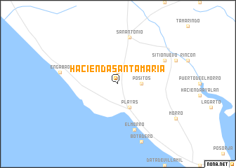
Hacienda Santa María (Guayas, Ecuador)Hacienda Santa María is a town in the Guayas region of Ecuador. An overview map of the region around Hacienda Santa María is displayed below.
regional and 3d topo map of Hacienda Santa María, Ecuador ::
Hacienda Santa María airports ::
The nearest airport is GYE - Guayaquil Jose Joaquin De Olmedo Intl, located 75.5 km north east of Hacienda Santa María.
Other airports nearby include SNC - Salinas General Ulpiano Paez (78.7 km north west), MCH - Machala General Manuel Serrano (88.6 km south east), TBP - Tumbes Pedro Canga (105.3 km south), CUE - Cuenca Mariscal Lamar (160.6 km east), Nearby towns ::
Hacienda Bella Esperanza (1.9km north) //
La Florida (3.7km east) //
Positos (3.7km east) //
Playas (4.1km south east) //
San Antonio (7.6km north) //
ElMorro (7.7km south) //
San Miguel (8.3km north east) //
Sitio Nuevo (8.3km north east) //
[all distances 'as the bird flies' and approximate] 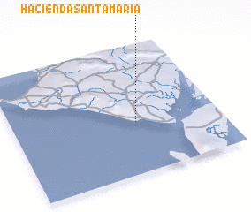 Places with similar names to Hacienda Santa María, Ecuador ::
// Hacienda Santa María (CR)
// Hacienda Santa María (EC)
// Hacienda Santa María (EC)
// Hacienda Santa María (EC)
// Hacienda Santa María (EC)
// Hacienda Santa Maria (US)
Disclaimer :: Information on this page comes without warranty of any kind |
||
|
Where is Hacienda Santa María? Elevation and coordinates ::
Latitude (lat): 2°36'0"S Longitude (lon): 80°24'0"W
Elevation (approx.): 16m (map arrows pan, magnifying glasses zoom) |
||
|
Visiting Hacienda Santa María? Hotel/Accommodation ::
Book a hotel in Hacienda Santa María Travel Guide ::
Buy a travel guide for Ecuador rental cars ::
car rental offers GPS waypoint ::
download a GPX waypoint (PoI) of Hacienda Santa María for your GPS receiver
|
||