|
search place name
|
||
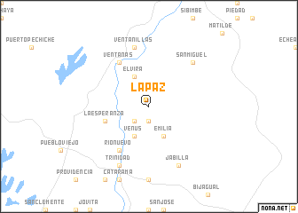
La Paz (Los Ríos, Ecuador)La Paz is a town in the Los Ríos region of Ecuador. An overview map of the region around La Paz is displayed below.
regional and 3d topo map of La Paz, Ecuador ::
La Paz airports ::
The nearest airport is GYE - Guayaquil Jose Joaquin De Olmedo Intl, located 88.3 km south west of La Paz.
Other airports nearby include ATF - Ambato Chachoan (100.7 km east), PVO - Portoviejo Reales Tamarindos (126.2 km north west), MEC - Manta Eloy Alfaro Intl (151.5 km north west), CUE - Cuenca Mariscal Lamar (161.6 km south), Nearby towns ::
Amalia (1.9km south) //
Vicoca (1.9km south) //
Loma Larga (2.6km south west) //
Emilia (4.1km south east) //
Venus (4.1km south west) //
Elvira (4.1km north west) //
La Esperanza (5.9km west) //
Ventanas (6.7km north west) //
Río Nuevo (6.7km south west) //
Ventanillas (7.6km north) //
San Miguel (7.9km north east) //
Jabilla (8.3km south east) //
Trinidad (8.3km south west) //
[all distances 'as the bird flies' and approximate]  Places with similar names to La Paz, Ecuador ::
Disclaimer :: Information on this page comes without warranty of any kind |
||
|
Where is La Paz? Elevation and coordinates ::
Latitude (lat): 1°30'0"S Longitude (lon): 79°26'0"W
Elevation (approx.): 19m (map arrows pan, magnifying glasses zoom) |
||
|
Visiting La Paz? Hotel/Accommodation ::
Book a hotel in La Paz Travel Guide ::
Buy a travel guide for Ecuador rental cars ::
car rental offers GPS waypoint ::
download a GPX waypoint (PoI) of La Paz for your GPS receiver
|
||