|
search place name
|
||
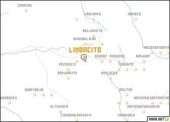
Limoncito (Guayas, Ecuador)Limoncito is a town in the Guayas region of Ecuador. An overview map of the region around Limoncito is displayed below.
regional and 3d topo map of Limoncito, Ecuador ::
Limoncito airports ::
The nearest airport is GYE - Guayaquil Jose Joaquin De Olmedo Intl, located 52.3 km east of Limoncito.
Other airports nearby include SNC - Salinas General Ulpiano Paez (71.1 km west), MCH - Machala General Manuel Serrano (124.1 km south), PVO - Portoviejo Reales Tamarindos (130.6 km north), MEC - Manta Eloy Alfaro Intl (145.2 km north), Nearby towns ::
Cavino (0.0km north) //
Villacrés (1.9km west) //
Buenavista (2.6km north west) //
G. Muñoz (3.7km east) //
Simón Bolívar (3.7km north) //
Pozo Seco (4.1km south west) //
San Juanito (5.2km south west) //
Hacienda Victoria (5.2km north east) //
Las Juntas (5.2km north east) //
Díaz (5.6km east) //
Bellavista (5.9km north) //
Don Lucas (6.7km south east) //
Río de Miel (7.4km east) //
Esperanza (7.6km east) //
San Jacinto (10.5km south west) //
[all distances 'as the bird flies' and approximate] 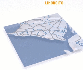 Places with similar names to Limoncito, Ecuador ::
// Lemon City (US)
// Limoncito (PA)
// Limoncito (CU)
// Limoncito (CU)
// Lumineşti (RO)
// Lumineşti (RO)
// Lumineşti (RO)
// La Mansita (CO)
// Limoncito (CO)
// Limoncito (CO)
Disclaimer :: Information on this page comes without warranty of any kind |
||
|
Where is Limoncito? Elevation and coordinates ::
Latitude (lat): 2°13'0"S Longitude (lon): 80°21'0"W
Elevation (approx.): 154m (map arrows pan, magnifying glasses zoom) |
||
|
Visiting Limoncito? Hotel/Accommodation ::
Book a hotel in Limoncito Travel Guide ::
Buy a travel guide for Ecuador rental cars ::
car rental offers GPS waypoint ::
download a GPX waypoint (PoI) of Limoncito for your GPS receiver
|
||