|
search place name
|
||
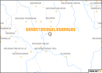
San Antonio de las Aradas (Loja, Ecuador)San Antonio de las Aradas is a town in the Loja region of Ecuador. An overview map of the region around San Antonio de las Aradas is displayed below.
regional and 3d topo map of San Antonio de las Aradas, Ecuador ::
San Antonio de las Aradas airports ::
The nearest airport is MCH - Machala General Manuel Serrano, located 134.8 km north west of San Antonio de las Aradas.
Other airports nearby include TBP - Tumbes Pedro Canga (140.2 km north west), PIU - Piura Capitan Fap Guillermo Concha Iberico (164.8 km south west), CUE - Cuenca Mariscal Lamar (168.0 km north), TYL - Talara Capitan Montes (207.3 km west), Nearby towns ::
Hacienda Paloquin (3.7km north) //
Hacienda Tablón (5.2km south west) //
Quilanga (5.6km north) //
Hacienda Conduryacu (5.9km south) //
Hacienda Santa Bárbara (6.7km north west) //
Hacienda La Cría (7.9km north west) //
El Lucero (9.2km south west) //
El Ingenio (9.3km south east) //
[all distances 'as the bird flies' and approximate] 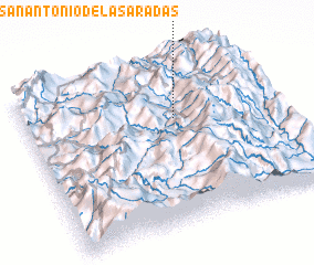 Places with similar names to San Antonio de las Aradas, Ecuador :: Disclaimer :: Information on this page comes without warranty of any kind |
||
|
Where is San Antonio de las Aradas? Elevation and coordinates ::
Latitude (lat): 4°21'0"S Longitude (lon): 79°24'0"W
Elevation (approx.): 1462m (map arrows pan, magnifying glasses zoom) |
||
|
Visiting San Antonio de las Aradas? Hotel/Accommodation ::
Book a hotel in San Antonio de las Aradas Travel Guide ::
Buy a travel guide for Ecuador rental cars ::
car rental offers GPS waypoint ::
download a GPX waypoint (PoI) of San Antonio de las Aradas for your GPS receiver
|
||