|
search place name
|
||
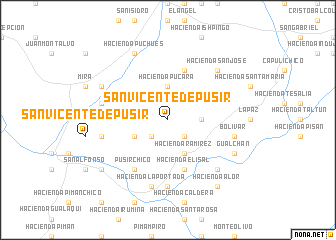
San Vicente de Pusir (Carchi, Ecuador)San Vicente de Pusir is a town in the Carchi region of Ecuador. An overview map of the region around San Vicente de Pusir is displayed below.
regional and 3d topo map of San Vicente de Pusir, Ecuador ::
San Vicente de Pusir airports ::
The nearest airport is TUA - Tulcan Teniente Coronel Luis A Mantilla, located 42.1 km north east of San Vicente de Pusir.
Other airports nearby include IPI - Ipiales San Luis (49.2 km north east), UIO - Quito Mariscal Sucre Intl (94.2 km south west), PSO - Pasto Antonio Narino (121.8 km north east), OCC - Coca Francisco De Orellana (152.4 km south east), Nearby towns ::
Hacienda San Francisco (2.6km south west) //
Los Andes (2.6km south east) //
Hacienda Pucará (3.7km north) //
Hacienda Monjas (3.7km east) //
Hacienda Puntales (3.7km east) //
Hacienda El Tambo (4.1km south west) //
Hacienda Ramírez (4.1km south east) //
Hacienda Chulunhuasi (4.1km south east) //
García Moreno (5.9km north) //
Hacienda Cunquer (5.9km south) //
Hacienda Elisal (5.9km south) //
Pusir Chico (6.7km south west) //
Hacienda Garbanzal (7.4km south) //
Hacienda San Nicolás (7.6km west) //
Bolívar (7.6km east) //
Hacienda San Vicente (7.6km west) //
Hacienda La Portada (7.6km south) //
Hacienda La Ranchería (7.9km north east) //
Hacienda San José (7.9km north east) //
Hacienda Angelina (7.9km south east) //
Hacienda Puchués (8.3km north west) //
Hacienda San José (8.3km north west) //
Hacienda Pueblo Viejo (8.3km north west) //
Gualchán (8.3km south east) //
Hacienda Alor (9.3km south east) //
Hacienda San Alfonso (9.3km south west) //
[all distances 'as the bird flies' and approximate]  Places with similar names to San Vicente de Pusir, Ecuador ::
// San Vicente de Pusir (EC)
Disclaimer :: Information on this page comes without warranty of any kind |
||
|
Where is San Vicente de Pusir? Elevation and coordinates ::
Latitude (lat): 0°31'0"S Longitude (lon): 77°57'0"W
Elevation (approx.): 2798m (map arrows pan, magnifying glasses zoom) |
||
|
Visiting San Vicente de Pusir? Hotel/Accommodation ::
Book a hotel in San Vicente de Pusir Travel Guide ::
Buy a travel guide for Ecuador rental cars ::
car rental offers GPS waypoint ::
download a GPX waypoint (PoI) of San Vicente de Pusir for your GPS receiver
|
||