|
search place name
|
||
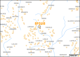
Afguia (Timor Timur, East Timor)Afguia is a town in the Timor Timur region of East Timor. An overview map of the region around Afguia is displayed below.
regional and 3d topo map of Afguia, East Timor ::
Afguia airports ::
The nearest airport is DIL - Dili Presidente Nicolau Lobato Intl, located 127.2 km west of Afguia.
Nearby towns ::
Alaua (0.1km north) //
Alaua (0.1km north east) //
Caidauai (1.1km south) //
Buboha (1.6km south east) //
Tirifalo (1.8km south east) //
Baguia (1.8km west) //
Adoi (1.8km south east) //
Uasufa (2.0km west) //
Alaua 2 (2.1km west) //
Alaua Leten (2.3km west) //
Maurubiassa (2.3km west) //
Sorocama (2.4km north west) //
Alaua 1 (2.5km west) //
Maurubiassa (2.8km west) //
Neoledade (3.0km west) //
Iraosso (3.1km north west) //
Nelouai (3.1km south west) //
Iraosso (3.3km north west) //
Lauaba (3.6km south east) //
Samalari (3.7km south west) //
Defauassi (3.7km north east) //
Beheissi (3.8km west) //
Bahatata (3.9km south west) //
Afalari (3.9km west) //
Tatadere (4.0km south west) //
Namanei (4.0km west) //
Taubere (4.0km north) //
Tirifalo (4.0km east) //
Builicorae (4.1km south west) //
[all distances 'as the bird flies' and approximate] 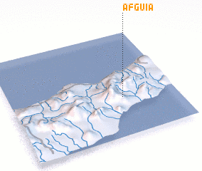 Places with similar names to Afguia, East Timor ::
Disclaimer :: Information on this page comes without warranty of any kind |
||
|
Where is Afguia? Elevation and coordinates ::
Latitude (lat): 8°37'32"S Longitude (lon): 126°40'38"E
Elevation (approx.): 312m (map arrows pan, magnifying glasses zoom) |
||
|
Visiting Afguia? Hotel/Accommodation ::
Book a hotel in Afguia Travel Guide ::
Buy a travel guide for East Timor rental cars ::
car rental offers GPS waypoint ::
download a GPX waypoint (PoI) of Afguia for your GPS receiver
|
||