|
search place name
|
||
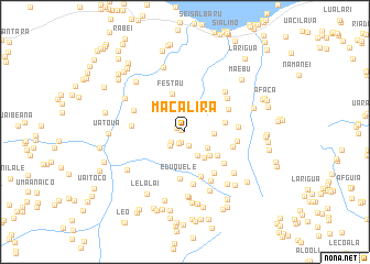
Macalira (Timor Timur, East Timor)Macalira is a town in the Timor Timur region of East Timor. An overview map of the region around Macalira is displayed below.
regional and 3d topo map of Macalira, East Timor ::
Macalira airports ::
The nearest airport is DIL - Dili Presidente Nicolau Lobato Intl, located 110.3 km west of Macalira.
Nearby towns ::
Bocilai (0.4km north west) //
Macalaco (0.9km north west) //
Defadae (1.1km south) //
Luborice (1.3km south west) //
Chefamuai (1.4km south) //
Larimuta (1.7km south west) //
Larubo (2.0km south west) //
Letemumo (2.7km south east) //
Baguia (2.8km south east) //
Samadae (2.9km east) //
Tabere (3.2km south east) //
Lebene (3.4km south east) //
Festau (4.0km north) //
Butileo (4.1km south east) //
Mumana (4.2km east) //
Eduquele (4.8km south) //
Bubolita (4.8km south) //
Abafala (4.9km north east) //
Quelicai (5.0km south east) //
Lacolio (5.1km south east) //
Uaitame (5.1km east) //
Uaitame (5.3km east) //
Ruta (5.3km south) //
Wabere (5.4km east) //
Uatoue (5.4km west) //
Guruca (5.5km north east) //
Lacudala (5.6km south east) //
Lilouarica (5.6km north west) //
Cotaissi (5.7km north east) //
[all distances 'as the bird flies' and approximate] 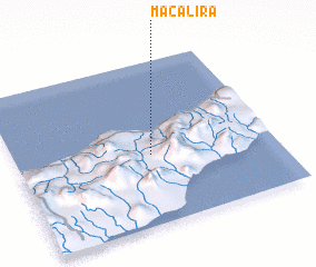 Places with similar names to Macalira, East Timor ::
Disclaimer :: Information on this page comes without warranty of any kind |
||
|
Where is Macalira? Elevation and coordinates ::
Latitude (lat): 8°34'27"S Longitude (lon): 126°31'34"E
Elevation (approx.): 433m (map arrows pan, magnifying glasses zoom) |
||
|
Visiting Macalira? Hotel/Accommodation ::
Book a hotel in Macalira Travel Guide ::
Buy a travel guide for East Timor rental cars ::
car rental offers GPS waypoint ::
download a GPX waypoint (PoI) of Macalira for your GPS receiver
|
||