|
search place name
|
||
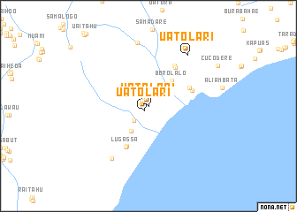
Uatolari (Timor Timur, East Timor)Uatolari is a town in the Timor Timur region of East Timor. An overview map of the region around Uatolari is displayed below.
regional and 3d topo map of Uatolari, East Timor ::
Uatolari airports ::
The nearest airport is DIL - Dili Presidente Nicolau Lobato Intl, located 115.1 km west of Uatolari.
Nearby towns ::
Uatolari (0.8km south west) //
Matahoi (0.9km north west) //
Umaquic (1.0km north west) //
Saebau (2.4km north east) //
Naidala (2.4km north east) //
Pafuloain (2.5km south west) //
Uaitame (2.9km north east) //
Darabai (3.2km north east) //
Fohomano (3.4km north east) //
Dinbau (3.7km north east) //
Makadiki (3.8km south west) //
Borolalo (4.3km north east) //
Vessoro (5.6km north east) //
Biadae (5.7km south west) //
Aliambata (5.8km east) //
Lugassa (5.9km south west) //
Babulo (5.9km north east) //
Afloicai (6.0km north east) //
Siquilari (8.1km north) //
Fatoalas (8.1km south west) //
Uatolari (8.1km north east) //
Cucodere (9.9km north east) //
[all distances 'as the bird flies' and approximate] 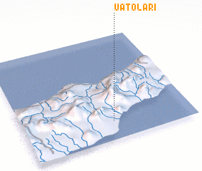 Places with similar names to Uatolari, East Timor ::
Disclaimer :: Information on this page comes without warranty of any kind |
||
|
Where is Uatolari? Elevation and coordinates ::
Latitude (lat): 8°49'16"S Longitude (lon): 126°32'1"E
Elevation (approx.): 21m (map arrows pan, magnifying glasses zoom) |
||
|
Visiting Uatolari? Hotel/Accommodation ::
Book a hotel in Uatolari Travel Guide ::
Buy a travel guide for East Timor rental cars ::
car rental offers GPS waypoint ::
download a GPX waypoint (PoI) of Uatolari for your GPS receiver
|
||