|
search place name
|
||
Umaheuk (Timor Timur, East Timor)Umaheuk is a town in the Timor Timur region of East Timor. An overview map of the region around Umaheuk is displayed below.
regional and 3d topo map of Umaheuk, East Timor ::

Umaheuk airports ::
The nearest airport is DIL - Dili Presidente Nicolau Lobato Intl, located 34.3 km west of Umaheuk.
Nearby towns ::
Labubu (1.2km north) //
Umaheuk (2.1km north west) //
Anicalau (2.6km west) //
Robai (3.1km north west) //
Matilau (3.4km south) //
Tuha (3.6km north east) //
Fahilacor (4.4km south west) //
Rehatu (4.7km north west) //
Reabuticeon (4.8km north east) //
Bua (4.9km north) //
Sabomata (5.0km west) //
Hatobuti (5.6km west) //
Maloroc (6.4km north east) //
Sibarceon (6.4km south) //
Hatuconan (7.0km north) //
Hatomera (7.1km west) //
Aikurus (7.6km west) //
Bahadic (7.6km north east) //
Bahadic (7.6km north east) //
Luquisa (7.8km south west) //
Caimauc Quic (7.9km south west) //
Raimerahei (8.4km south west) //
Kera (8.5km north east) //
Tahagamo (10.6km north east) //
Sucatin (10.6km north east) //
Reododok (12.0km north east) //
[all distances 'as the bird flies' and approximate] 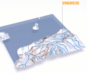 Places with similar names to Umaheuk, East Timor ::
// Umaheuk (TP)
// Umu Ohie Uku (NG)
Disclaimer :: Information on this page comes without warranty of any kind |
||
|
Where is Umaheuk? Elevation and coordinates ::
Latitude (lat): 8°37'36"S Longitude (lon): 125°49'34"E
Elevation (approx.): 606m (map arrows pan, magnifying glasses zoom) |
||
|
Visiting Umaheuk? Hotel/Accommodation ::
Book a hotel in Umaheuk Travel Guide ::
Buy a travel guide for East Timor rental cars ::
car rental offers GPS waypoint ::
download a GPX waypoint (PoI) of Umaheuk for your GPS receiver
|
||